Fichier:Tangier Zone txu-oclc-6949452-ni30-1.jpg

Taille de cet aperçu : 410 × 599 pixels. Autres résolutions : 164 × 240 pixels | 329 × 480 pixels | 949 × 1 386 pixels.
Fichier d’origine (949 × 1 386 pixels, taille du fichier : 1,2 Mio, type MIME : image/jpeg)
Ce fichier et sa description proviennent de Wikimedia Commons.
Description
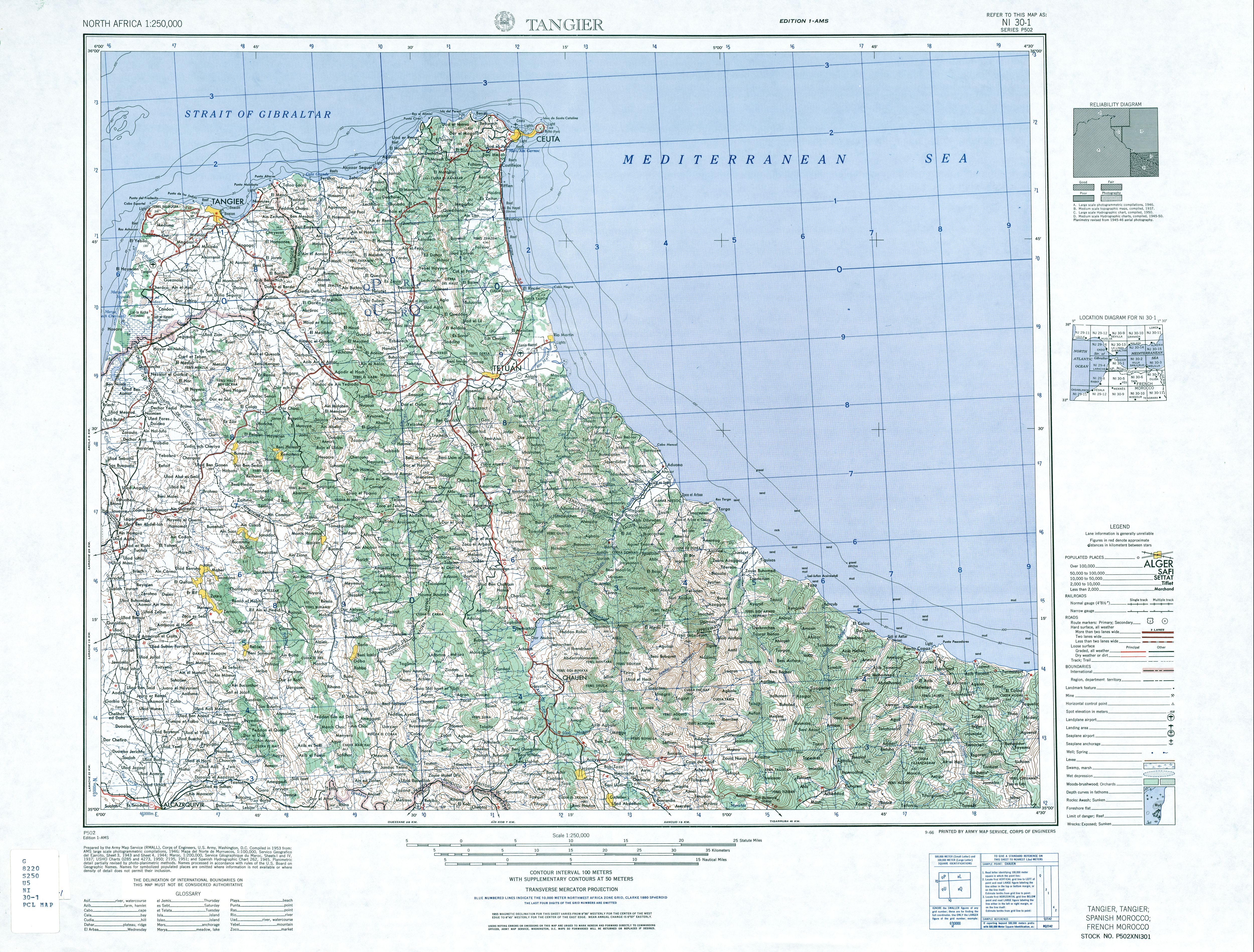
| Description | English: map of the area of the former International Zone of Tangier, Morocco |
| Date | |
| Source | http://www.lib.utexas.edu/maps/ams/north_africa/txu-oclc-6949452-ni30-1.jpg |
| Auteur | Army Map Service |
Conditions d’utilisation
Cette image est une œuvre d'un soldat ou d'un employé de l'U.S. Army, réalisée dans le cadre de ses activités professionnelles. En tant qu'œuvre du gouvernement fédéral des États-Unis d'Amérique, cette image fait partie du domaine public. |  |
-
Historique du fichier
Cliquer sur une date et heure pour voir le fichier tel qu'il était à ce moment-là.
| Date et heure | Vignette | Dimensions | Utilisateur | Commentaire | |
|---|---|---|---|---|---|
| actuel | 29 novembre 2017 à 09:14 | | 949 × 1 386 (1,2 Mio) | ديفيد عادل وهبة خليل 2 | Removed border by cropping 3 % horizontally and 2 % vertically using CropTool with precise mode. |
| 6 juin 2010 à 21:40 |  | 976 × 1 419 (1,26 Mio) | Ratzer | {{Information |Description={{en|1=map of the area of the former International Zone of Tangier, Morocco}} |Source=http://www.lib.utexas.edu/maps/ams/north_africa/txu-oclc-6949452-ni30-1.jpg |Author=Army Map Service |Date=1953 |Permission= |other_versions= |
Utilisation du fichier
La page suivante utilise ce fichier :
Usage global du fichier
Les autres wikis suivants utilisent ce fichier :
- Utilisation sur ar.wikipedia.org
- Utilisation sur br.wikipedia.org
- Utilisation sur de.wikipedia.org
- Utilisation sur en.wikipedia.org
- Utilisation sur id.wikipedia.org
- Utilisation sur it.wikipedia.org
- Utilisation sur ja.wikipedia.org
- Utilisation sur nl.wikipedia.org
- Utilisation sur pl.wikipedia.org
- Utilisation sur pt.wikipedia.org
- Utilisation sur ru.wikipedia.org
- Utilisation sur simple.wikipedia.org
- Utilisation sur uk.wikipedia.org
- Utilisation sur ur.wikipedia.org
- Utilisation sur zh.wikipedia.org
🔥 Top keywords: Wikipédia:Accueil principalSpécial:RechercheCorentin MoutetChloé PaquetManon AubryAlexander ShevchenkoSébastien DeloguJordan BardellaNovak DjokovicAlejandro Davidovich FokinaGaël MonfilsVarvara GrachevaArthur RinderknechListe des listes aux élections européennes de 2024 en FranceElina SvitolinaNaomi OsakaRafael NadalBenyamin NetanyahouSondages sur les élections européennes de 2024Meyer HabibAlexander ZverevFête-DieuValérie HayerCasper RuudAryna SabalenkaFichier:Cleopatra poster.jpgStanislas WawrinkaSCH (rappeur)Raphaël GlucksmannChatGPTDavid GoffinRima HassanLa Vingt-cinquième Heure (film)François-Xavier BellamyLéon DeffontainesAmélie MauresmoMarion MaréchalPalestine (État)Vincent Kompany