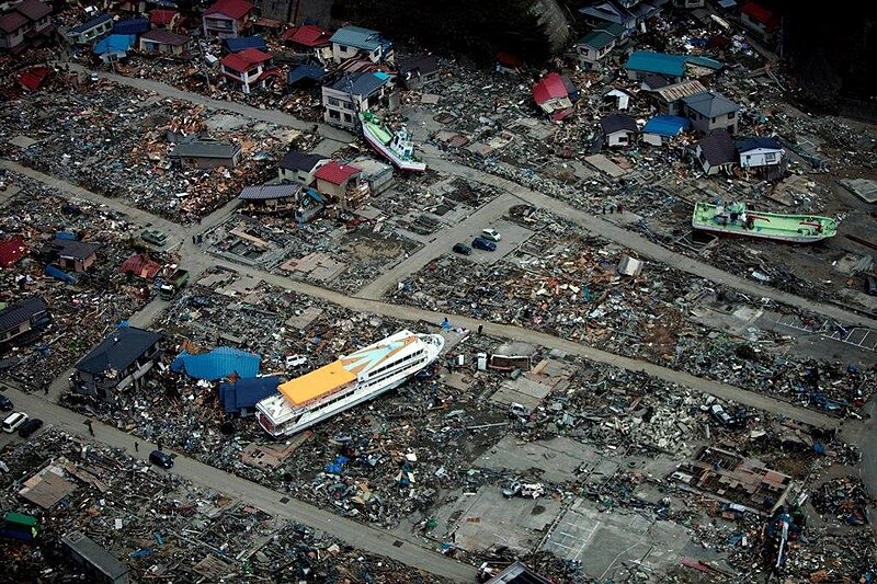
படிமம்:US Navy 110320-M-0145H-063 A large ferry boat rests inland amidst destroyed houses after a 9.0 earthquake and subsequent tsunami struck Japan March.jpg

இந்த முன்னோட்டத்தின் அளவு: 800 × 533 படப்புள்ளிகள் . மற்ற பிரிதிறன்கள்: 320 × 213 படப்புள்ளிகள் | 640 × 427 படப்புள்ளிகள் | 1,023 × 682 படப்புள்ளிகள் .
மூலக்கோப்பு (1,023 × 682 படவணுக்கள், கோப்பின் அளவு: 221 KB, MIME வகை: image/jpeg)
கோப்பின் வரலாறு
குறித்த நேரத்தில் இருந்த படிமத்தைப் பார்க்க அந்நேரத்தின் மீது சொடுக்கவும்.
| நாள்/நேரம் | நகம் அளவு சிறுபடம் | அளவுகள் | பயனர் | கருத்து | |
|---|---|---|---|---|---|
| தற்போதைய | 02:08, 30 மார்ச்சு 2011 |  | 1,023 × 682 (221 KB) | BotMultichillT | == {{int:filedesc}} == {{Information |description={{en|1=AICHI, Japan (March 20, 2011) A large ferry boat rests inland amidst destroyed houses after a 9.0 earthquake and subsequent tsunami struck Japan March 11. As part of Operation Tomodachi, the 31st Ma |
கோப்பு பயன்பாடு
பின்வரும் பக்க இணைப்புகள்இப் படிமத்துக்கு இணைக்கபட்டுள்ளது(ளன):
கோப்பின் முழுமையான பயன்பாடு
கீழ்கண்ட மற்ற விக்கிகள் இந்த கோப்பை பயன்படுத்துகின்றன:
- de.wikipedia.org-திட்டத்தில் இதன் பயன்பாடு
- en.wikipedia.org-திட்டத்தில் இதன் பயன்பாடு
- en.wikivoyage.org-திட்டத்தில் இதன் பயன்பாடு
- ja.wikipedia.org-திட்டத்தில் இதன் பயன்பாடு
- ja.wikinews.org-திட்டத்தில் இதன் பயன்பாடு
- ko.wikipedia.org-திட்டத்தில் இதன் பயன்பாடு
- ms.wikipedia.org-திட்டத்தில் இதன் பயன்பாடு
- pt.wikipedia.org-திட்டத்தில் இதன் பயன்பாடு
- sl.wikipedia.org-திட்டத்தில் இதன் பயன்பாடு
- sr.wikipedia.org-திட்டத்தில் இதன் பயன்பாடு
- sv.wikipedia.org-திட்டத்தில் இதன் பயன்பாடு
மேனிலைத் தரவு
🔥 Top keywords: தமிழிசை சௌந்தரராஜன்முதற் பக்கம்சிறப்பு:Searchசே குவேராவிரிஞ்சிபுரம் வழித்துணைநாதர் கோயில்நடராசர்சுப்பிரமணிய பாரதிதமிழ்பாரதிதாசன்ஜம்புத் தீவு பிரகடனம்பவன் கல்யாண்மரம்திருக்குறள்மருது பாண்டியர்தமிழ்நாட்டின் மாவட்டங்கள்பெண் தமிழ்ப் பெயர்கள்நாலடியார்அரச மரம்பதினெண் கீழ்க்கணக்குஎட்டுத்தொகைகாமராசர்ஐம்பெருங் காப்பியங்கள்அண்ணாமலை குப்புசாமிதமிழ்த் திரைப்படங்களின் பட்டியல் (ஆண்டு வரிசை)பத்துப்பாட்டுவிநாயகர் அகவல்தமிழ்ப் பழமொழிகளின் பட்டியல்சிறப்பு:RecentChangesவிக்கிரவாண்டி (சட்டமன்றத் தொகுதி)தமிழ்நாடுஉடுக்கைதியாகத் திருநாள்திருவள்ளுவர்இந்திய வானியலின் 27 நட்சத்திரங்கள்குமரகுருபரர்ஆண் தமிழ்ப் பெயர்கள்பதினெண்மேற்கணக்குசிலப்பதிகாரம்பீப்பாய்

