Nièvre
Nièvre is a department in the centre of France, in the Bourgogne-Franche-Comté region. It is named after the Nièvre river, a tributary of the Loire. Its prefecture and largest city is Nevers.
Nièvre | |
|---|---|
 Prefecture building of the Nièvre department, in Nevers | |
 Flag  Coat of arms | |
 Location of Nièvre in France | |
| Coordinates: 47°05′N 03°30′E / 47.083°N 3.500°E | |
| Country | France |
| Region | Bourgogne-Franche-Comté |
| Département | 4 March 1790 |
| Prefecture | Nevers |
| Subprefecture | Château-Chinon, Clamecy, Cosne-Cours-sur-Loire |
| Government | |
| • President | Patrice Joly[1] |
| Area | |
| • Total | 6,816.7 km2 (2,631.9 sq mi) |
| Population (2014)[3] | |
| • Total | 213,569 |
| • Density | 31/km2 (81/sq mi) |
| Demonym | Nivernais |
| Time zone | UTC+1 (CET) |
| • Summer (DST) | UTC+2 (CEST) |
| ISO 3166 code | FR-58 |
| Arrondissements | 4 |
| Cantons | 17 |
| Communes | 309 |
| Website | http://www.nievre.fr |
History
changeNièvre is one of the original 83 departments created during the French Revolution on 4 March 1790 with Nevers as its capital. It was formed from part of the old province of Nivernais and its name was written at first as Nyèvre.[4]
It was divided in nine districts: Nevers, Saint-Pierre-le-Moutier, Decize, Moulins-Engilbert, Château-Chinon, Corbigny, Clamecy, Cosne and La Charité.
In 1800, with the creation of the arrondissements in France, the nine districts were changed into four arrondissements: Nevers, Château-Chinon, Clamecy and Cosne.[5]
On 10 September 1926, the arrondissement of Cosne was eliminated but in 1943 it became again an arrondissement of the department.[5]
Geography
change
Nièvre is part of the Bourgogne-Franche-Comté region. It has an area of 6,816.7 km2 (2,632 sq mi).[2] The highest point of the department is Mont Préneley (46°57′24″N 4°0′7″E / 46.95667°N 4.00194°E), 855 m (2,805 ft) high;[6] it is in the commune Glux-en-Glenne.
The department borders with six departments in three regions:
- Bourgogne-Franche-Comté region
- Yonne (north)
- Côte-d'Or (east)
- Saône-et-Loire (southeast)
- Auvergne-Rhône-Alpes region
- Allier (southwest)
- Centre-Val de Loire region
There are three main geographical zones in the department:[7]
- Eastern zone, with small hills covered with forests; here is the Parc Naturel Régional du Morvan ("Morvan regional natural park").
- Central zone, an agricultural zone.
- Western zone, a zone organised along a north-south line formed by the valley of the Loire river; it is the zone of the department with higher population.
The main rivers in the department are the Loire, that makes most of the western border, with its tributaries Allier and Aron; and the Yonne, with its tributary Cure.
Climate
changeThe Köppen climate classification type for the climate at Nevers is an "Oceanic climate" (also known as Maritime Temperate climate) and of the subtype "Cfb".[8]
It rains in all seasons but precipitations are more important in the eastern zone, in the Morvan, and weaker in the Loire valley.[9]
Administration
changeNièvre is managed by the Departmental Council of Nièvre in Nevers. The department is part of the Bourgogne-Franche-Comté region.
Administrative divisions
changeThere are 4 arrondissements (districts), 17 cantons and 309 communes (municipalities) in Nièvre.[10]
| INSEE code | Arrondissement | Capital | Population[11] (2014) | Area[12] (km²) | Density (Inh./km²) | Communes |
|---|---|---|---|---|---|---|
| 581 | Château-Chinon (Ville) | Château-Chinon (Ville) | 25,717 | 1,929.1 | 13.3 | 80 |
| 582 | Clamecy | Clamecy | 24,993 | 1,464.0 | 17.1 | 84 |
| 583 | Nevers | Nevers | 118,087 | 2,020.3 | 58.5 | 82 |
| 584 | Cosne-Cours-sur-Loire | Cosne-Cours-sur-Loire | 44,772 | 1,403.3 | 31.9 | 63 |
The following is a list of the 17 cantons of the Nièvre department (with their INSEE codes), following the French canton reorganisation which came into effect in March 2015:[13]
- La Charité-sur-Loire (5801)
- Château-Chinon (5802)
- Clamecy (5803)
- Corbigny (5804)
- Cosne-Cours-sur-Loire (5805)
- Decize (5806)
- Fourchambault (5807)
- Guérigny (5808)
- Imphy (5809)
- Luzy (5810)
- Nevers-1 (5811)
- Nevers-2 (5812)
- Nevers-3 (5813)
- Nevers-4 (5814)
- Pouilly-sur-Loire (5815)
- Saint-Pierre-le-Moûtier (5816)
- Varennes-Vauzelles (5817)
Demographics
changeThe inhabitants of Nièvre are known, in French, as Nivernais (women: Nivernaises).[14]
Nièvre had a population, in 2014, of 213,569,[3] for a population density of 31.3 inhabitants/km2. The arrondissement of Nevers, with 118,087 inhabitants, is the arrondissement with more inhabitants.[11]
Evolution of the population in Nièvre

The 10 communes with more inhabitants in the department are:[11]
| City | Population[11] (2014) | Arrondissement |
|---|---|---|
| Nevers | 34,485 | Nevers |
| Cosne-Cours-sur-Loire | 10,553 | Cosne-Cours-sur-Loire |
| Varennes-Vauzelles | 9,467 | Nevers |
| Decize | 5,626 | Nevers |
| La Charité-sur-Loire | 5,008 | Cosne-Cours-sur-Loire |
| Fourchambault | 4,456 | Nevers |
| Clamecy | 3,889 | Clamecy |
| Garchizy | 3,835 | Nevers |
| Marzy | 3,656 | Nevers |
| Coulanges-lès-Nevers | 3,591 | Nevers |
Gallery
change Ducal Palace in Nevers
 Notre-Dame of La Charité-sur-Loire
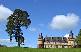 Château de Villemolin, Anthien
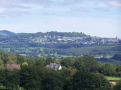 Château-Chinon (Ville): view from Dommartin
 Bridge over the Loire, at Cosne-Cours-sur-Loire


.jpg)

Related pages
changeReferences
change- ↑ "Le Président du Conseil Départemental" (in French). Conseil Départemental de la Nièvre. Archived from the original on 6 June 2017. Retrieved 10 June 2017.
- ↑ 2.0 2.1 "Département de la Nièvre (58)". Comparateur de territoire (in French). Institut national de la statistique et des études économiques - INSEE. Retrieved 10 June 2017.
- ↑ 3.0 3.1 "Populations légales 2014: Recensement de la population - Régions, départements, arrondissements, cantons et communes" (in French). Institut national de la statistique et des études économiques - INSEE. Retrieved 10 June 2017.
- ↑ "Description de la Nièvre". Le SPLAF (in French). Retrieved 5 October 2014.
- ↑ 5.0 5.1 "Historique de la Nièvre". Le SPLAF (in French). Retrieved 5 October 2014.
- ↑ "Mont Préneley, France". Peakbagger.com. Retrieved 10 June 2017.
- ↑ "Situation géographique de la Nièvre". CG58.fr. Conseil Général de la Nièvre. Archived from the original on 24 December 2015. Retrieved 5 October 2014.
- ↑ "Nevers, France - Köppen Climate Classification". Weatherbase. Retrieved 5 October 2014.
- ↑ "Chiffres-Clés". CG58.fr. Conseil Général de la Nièvre. Archived from the original on 24 December 2014. Retrieved 5 October 2014.
- ↑ "Département de la Nièvre (58)". Géographie administrative et d'étude (in French). Institut national de la statistique et des études économiques - INSEE. Retrieved 10 June 2017.
- ↑ 11.0 11.1 11.2 11.3 "Régions, départements, arrondissements, cantons et communes" (PDF). Populations légales 2014 (in French). Institut national de la statistique et des études économiques - INSEE. Retrieved 10 June 2017.
- ↑ "Département de la Nièvre (58)". Comparateur de territoire (in French). Institut national de la statistique et des études économiques - INSEE. Retrieved 10 June 2017.
- ↑ "Décret n° 2014-184 du 18 février 2014 portant délimitation des cantons dans le département de la Nièvre" (in French). Legifrance.gouv.fr. 18 February 2014. Retrieved 30 April 2015.
- ↑ "Nièvre (58)" (in French). habitants.fr. Retrieved 6 October 2014.
Other websites
change- Departmental Council website (in French)
- Prefecture website[permanent dead link] (in French)
- Agence de Développement Touristique de la Nièvre (in French)