Պատկեր:15th Arrondissement of Paris as seen from Pont de Bir-Hakeim 140507 1.jpg

Սկզբնական նիշք (7578 × 3991 փիքսել, նիշքի չափը՝ 13,67 ՄԲ, MIME-տեսակը՝ image/jpeg)
Ամփոփում
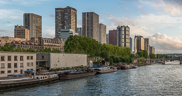
| Նկարագրում | English: The 15th arrondissement of Paris as seen from the Pont de Bir-Hakeim, shortly before sunset. Español: XV Distrito de París, Francia, visto desde el puente de Bir-Hakeim poco antes del atardecer.
| ||||
| Թվական | |||||
| Աղբյուր | Բեռնողի սեփական աշխատանք | ||||
| Հեղինակ | DXR |


| Տեսախցիկի տեղագրություն | | Այս և ուրիշ պատկերներ իրենց տեղագրությամբ OpenStreetMap |
|---|
Assessment
|
Այս պատկերը ընտրված է եղել որպես օրվա պատկեր 7 Մայիս 2024 թվականի համար: Պատկերը ունի հետևյալ նկարագրում՝ English: The 15th arrondissement of Paris as seen from the Pont de Bir-Hakeim, shortly before sunset Այլ լեզուներ՝ Deutsch: Das 15. Pariser Arrondissement gesehen von der Pont de Bir-Hakeim kurz vor Sonnenuntergang. English: The 15th arrondissement of Paris as seen from the Pont de Bir-Hakeim, shortly before sunset Español: XV Distrito de París, Francia, visto desde el puente de Bir-Hakeim poco antes del atardecer. Magyar: Párizs 15. kerülete a Pont de Bir-Hakeimről nézve, röviddel naplemente előtt Nederlands: Het 15e arrondissement van de Franse hoofdstad Parijs, gezien vanaf de Pont de Bir-Hakeim Português: 15.º arrondissement de Paris, França, visto da Ponte de Bir-Hakeim pouco antes do pôr do sol. |
| Panorama by DXR (Category) The photograph above is a panoramic image which was created by me, Daniel Vorndran, and uploaded here as User:DXR. Please note:
|


Արտոնագրում
- Դուք ազատ եք՝
- կիսվել ստեղծագործությամբ – պատճենել, տարածել և փոխանցել այս աշխատանքը։
- վերափոխել – ադապտացնել աշխատանքը
- Պահպանելով հետևյալ պայմանները'
- հղում – Դուք պետք է նշեք հեղինակի (իրավատիրոջ) հղումը:
- համանման տարածում – Եթե դուք ձևափոխում եք, փոխակերպում, կամ այս աշխատանքի հիման վրա ստեղծում եք նոր աշխատանք, ապա ձեր ստեղծածը կարող է տարածվել միայն նույն կամ համարժեք թույլատրագրով։
Նիշքի պատմություն
Մատնահարեք օրվան/ժամին՝ նիշքի այդ պահին տեսքը դիտելու համար։
| Օր/Ժամ | Մանրապատկեր | Օբյեկտի չափը | Մասնակից | Մեկնաբանություն | |
|---|---|---|---|---|---|
| ընթացիկ | 21:51, 3 Հունիսի 2014 | | 7578 × 3991 (13,67 ՄԲ) | DXR | Selective cloud brightening top right corner |
| 13:31, 2 Հունիսի 2014 |  | 7578 × 3991 (13,67 ՄԲ) | DXR | Slight straightening | |
| 13:09, 8 Մայիսի 2014 |  | 7595 × 4000 (14,38 ՄԲ) | DXR | Spots removed | |
| 12:59, 8 Մայիսի 2014 |  | 7595 × 4000 (14,3 ՄԲ) | DXR | VicuñaUploader 1.20 |
Նիշքի օգտագործում
Հետևյալ էջը հղվում է այս նիշքին՝
Նիշքի համընդհանուր օգտագործում
Հետևյալ այլ վիքիները օգտագործում են այս նիշքը՝
- Օգտագործումը ast.wikipedia.org կայքում
- Օգտագործումը av.wikipedia.org կայքում
- Օգտագործումը az.wikipedia.org կայքում
- Օգտագործումը crh.wikipedia.org կայքում
- Օգտագործումը cv.wikipedia.org կայքում
- Օգտագործումը de.wikivoyage.org կայքում
- Օգտագործումը el.wikipedia.org կայքում
- Օգտագործումը en.wikivoyage.org կայքում
- Օգտագործումը es.wikipedia.org կայքում
- Օգտագործումը fr.wikipedia.org կայքում
- Օգտագործումը fr.wikivoyage.org կայքում
- Օգտագործումը hu.wikipedia.org կայքում
- Օգտագործումը id.wikipedia.org կայքում
- Օգտագործումը it.wiktionary.org կայքում
- Օգտագործումը ka.wikipedia.org կայքում
- Օգտագործումը kk.wikipedia.org կայքում
- Օգտագործումը ko.wikipedia.org կայքում
- Օգտագործումը lez.wikipedia.org կայքում
- Օգտագործումը mdf.wikipedia.org կայքում
- Օգտագործումը mk.wikipedia.org կայքում
- Օգտագործումը myv.wikipedia.org կայքում
- Օգտագործումը os.wikipedia.org կայքում
- Օգտագործումը pt.wikipedia.org կայքում
- Օգտագործումը ro.wikipedia.org կայքում
- Օգտագործումը ru.wikipedia.org կայքում
- Օգտագործումը sah.wikipedia.org կայքում
- Օգտագործումը tt.wikipedia.org կայքում
- Օգտագործումը tyv.wikipedia.org կայքում
- Օգտագործումը udm.wikipedia.org կայքում
- Օգտագործումը uk.wikipedia.org կայքում
- Օգտագործումը vep.wikipedia.org կայքում
- Օգտագործումը vi.wikipedia.org կայքում
Տեսնել այս նիշքի ավելի համընդհանուր օգտագործումը: