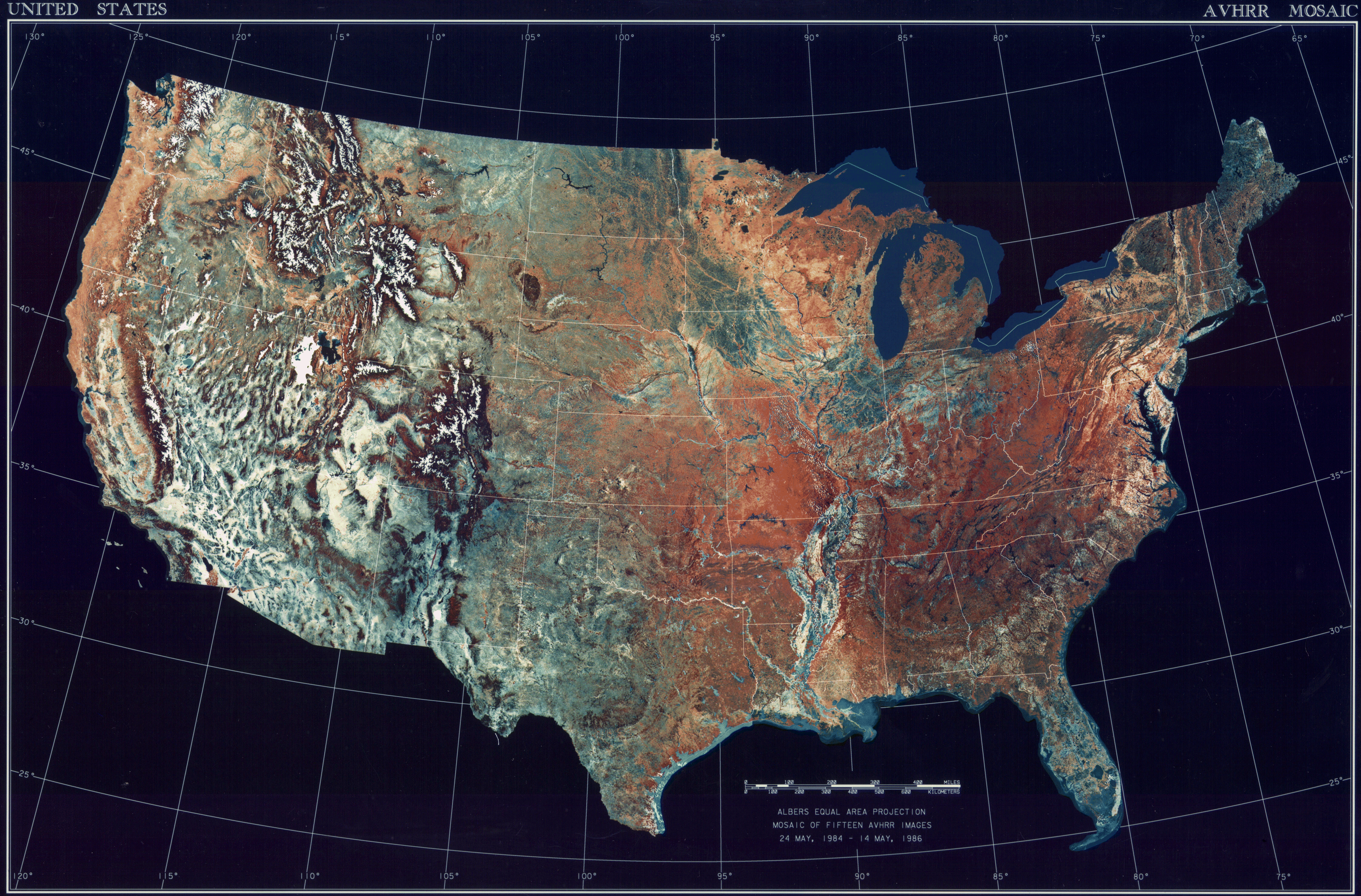
ચિત્ર:USATopographicalMap.jpg
આ પૂર્વાવલોકનનું કદ: ૮૦૦ × ૫૨૭ પિક્સેલ. અન્ય આવર્તનો: ૩૨૦ × ૨૧૧ પિક્સેલ | ૬૪૦ × ૪૨૨ પિક્સેલ | ૧,૦૨૪ × ૬૭૪ પિક્સેલ | ૧,૨૮૦ × ૮૪૩ પિક્સેલ | ૨,૫૬૦ × ૧,૬૮૬ પિક્સેલ | ૩,૧૯૯ × ૨,૧૦૭ પિક્સેલ.
મૂળભુત ફાઇલ (૩,૧૯૯ × ૨,૧૦૭ પીક્સલ, ફાઇલનું કદ: ૧૧.૧૯ MB, MIME પ્રકાર: image/jpeg)
સારાંશ:
| વર્ણન | Deutsch: Satellitenbild der 48 Zentralstaaten der Vereinigten Staaten. |
| તારીખ | ૨૪ મે ૧૯૮૪ - ૧૪ મે ૧૯૮૬ |
| સ્રોત | National Climactic Data Center/NOAA Satellite and Information Service |
| લેખક | U.S. Dept. of Commerce/National Climactic Data Center/NOAA Satellite and Information Service |
પરવાના
This image is in the public domain because it contains materials that originally came from the U.S. National Oceanic and Atmospheric Administration, taken or made as part of an employee's official duties. |
ફાઇલનો ઇતિહાસ
તારીખ/સમય ઉપર ક્લિક કરવાથી તે સમયે ફાઇલ કેવી હતી તે જોવા મળશે.
| તારીખ/સમય | લઘુચિત્ર | પરિમાણો | સભ્ય | ટિપ્પણી | |
|---|---|---|---|---|---|
| વર્તમાન | ૧૩:૩૬, ૨૫ ઓક્ટોબર ૨૦૧૩ | | ૩,૧૯૯ × ૨,૧૦૭ (૧૧.૧૯ MB) | McZusatz | compression (uploaded using chunked upload script) |
| ૨૩:૦૩, ૪ માર્ચ ૨૦૦૯ |  | ૩,૧૯૯ × ૨,૧૦૭ (૪૫૦ KB) | File Upload Bot (Magnus Manske) | {{BotMoveToCommons|en.wikipedia|year={{subst:CURRENTYEAR}}|month={{subst:CURRENTMONTHNAME}}|day={{subst:CURRENTDAY}}}} {{Information |Description={{en|Topographical map of the United States}} |Source=Transferred from [http://en.wikipedia.org en.wikipedia |
ફાઇલનો વપરાશ
આ ફાઇલ માં નીચેનું પાનું વપરાયેલું છે:
ફાઇલનો વ્યાપક ઉપયોગ
નીચેની બીજી વિકિઓ આ ફાઈલ વાપરે છે:
- ar.wikipedia.org પર વપરાશ
- arz.wikipedia.org પર વપરાશ
- ceb.wikipedia.org પર વપરાશ
- de.wikipedia.org પર વપરાશ
- el.wikipedia.org પર વપરાશ
- en.wikipedia.org પર વપરાશ
- es.wikipedia.org પર વપરાશ
- fa.wikipedia.org પર વપરાશ
- fr.wikipedia.org પર વપરાશ
- fy.wikipedia.org પર વપરાશ
- he.wikipedia.org પર વપરાશ
- ia.wikipedia.org પર વપરાશ
- incubator.wikimedia.org પર વપરાશ
- kn.wikipedia.org પર વપરાશ
- la.wikipedia.org પર વપરાશ
- lt.wikipedia.org પર વપરાશ
- mnw.wikipedia.org પર વપરાશ
- ms.wikipedia.org પર વપરાશ
- my.wikipedia.org પર વપરાશ
- pap.wikipedia.org પર વપરાશ
- sq.wikipedia.org પર વપરાશ
- sv.wikipedia.org પર વપરાશ
- sw.wikipedia.org પર વપરાશ
- ta.wikipedia.org પર વપરાશ
- tcy.wikipedia.org પર વપરાશ
- th.wikipedia.org પર વપરાશ
- tl.wikipedia.org પર વપરાશ
- uk.wikipedia.org પર વપરાશ
- www.wikidata.org પર વપરાશ
- yo.wikipedia.org પર વપરાશ
🔥 Top keywords: મુખપૃષ્ઠગુજરાતી ભાષામિઆ ખલીફાવલ્લભાચાર્યરાશીવિશેષ:શોધગુજરાતઝવેરચંદ મેઘાણીગુજરાતી અંકભારતનું બંધારણગુજરાતના જિલ્લાઓગુજરાત વિધાનસભાલોક સભાગુજરાતના લોકસભા મતવિસ્તારોગુજરાતીનરેન્દ્ર મોદીઅમદાવાદઓખાહરણઢાંચો:Lang-x/docઢાંચો:Wikidata Infobox/docભારતીય ચૂંટણી પંચભારતવશદિવ્ય ભાસ્કરભારતનાં રાજ્યો અને કેન્દ્રશાસિત પ્રદેશોબનાસકાંઠા લોક સભા મતવિસ્તારભારતના વડાપ્રધાનમટકું (જુગાર)મહાત્મા ગાંધીભારતનો ઇતિહાસકૃષ્ણમહાભારતસિંધુ ખીણની સંસ્કૃતિમહિનોસોમનાથવલ્લભભાઈ પટેલએકાદશી વ્રતક્ષત્રિયશ્રીમદ્ ભગવદ્ ગીતા