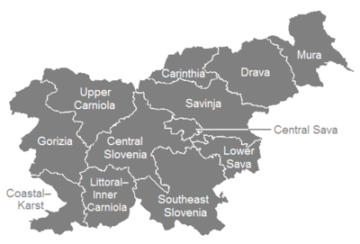
The statistical regions of Slovenia are 12 administrative entities created in 2000 for legal and statistical purposes.
| Statistical regions of Slovenia Statistične regije Slovenije (in Slovene) | |
|---|---|
 | |
| Category | Unitary state |
| Location | |
| Number | 12 Statistical regions |
| Populations | 41,606 (Central Sava) – 564,527 (Central Slovenia) |
| Areas | 264 km2 (102 sq mi) (Central Sava) – 2,675 km2 (1,033 sq mi) (Southeast Slovenia) |
| Government |
|
| Subdivisions | |
Division edit
By a decree in 2000, Slovenia has been divided into 12 statistical regions (NUTS-3 level), which are grouped in two cohesion regions (NUTS-2 level).[1]
The statistical regions have been grouped into two cohesion regions are:
- Eastern Slovenia (Vzhodna Slovenija – SI01), which groups the Mura, Drava, Carinthia, Savinja, Central Sava, Lower Sava, Southeast Slovenia, and Littoral–Inner Carniola regions.
- Western Slovenia (Zahodna Slovenija – SI02), which groups the Central Slovenia, Upper Carniola, Gorizia, and Coastal–Karst regions.
| Statistical regions | |||||
|---|---|---|---|---|---|
| English name | Slovenian name | Code | Largest city | Area (km2) | Population (2019) |
| Mura | pomurska | SI011 | Murska Sobota | 1,337 | 114,287 |
| Drava | podravska | SI012 | Maribor | 2,170 | 324,104 |
| Carinthia | koroška | SI013 | Slovenj Gradec | 1,041 | 70,588 |
| Savinja | savinjska | SI014 | Celje | 2,384 | 261,851 |
| Central Sava | zasavska | SI015 | Trbovlje | 264 | 41,606 |
| Lower Sava | posavska | SI016 | Krško | 885 | 70,067 |
| Southeast Slovenia | jugovzhodna Slovenija | SI017 | Novo Mesto | 2,675 | 144,032 |
| Littoral–Inner Carniola | primorsko-notranjska | SI018 | Postojna | 1,456 | 52,544 |
| Central Slovenia | osrednjeslovenska | SI021 | Ljubljana | 2,555 | 564,527 |
| Upper Carniola | gorenjska | SI022 | Kranj | 2,137 | 204,670 |
| Gorizia | goriška | SI023 | Nova Gorica | 2,325 | 117,616 |
| Coastal–Karst | obalno-kraška | SI024 | Koper | 1,044 | 115,016 |
Sources edit
See also edit
References edit
- ^ "Hierarchical list of the Nomenclature of territorial units for statistics - NUTS and the Statistical regions of Europe". European Union. Retrieved 2008-04-18.
External links edit
 Media related to Regions of Slovenia at Wikimedia Commons
- Regions. Stat.si (accessed 15 December 2020).
- Map of statistical regions of Slovenia. Geopedia.si (accessed 15 December 2020).