tóng-àn:Location-Europe-UNsubregions, Kosovo as part of Serbia.png

Seng khoàⁿ chiàm-liōng: 638 × 599 siōng-sò͘. Kî-thaⁿ--ê kái-sek-tō͘: 256 × 240 siōng-sò͘ | 511 × 480 siōng-sò͘ | 984 × 924 siōng-sò͘.
Choân kái-sek-tō͘ (984 × 924 siōng-sò͘ , tóng-àn chiàm-liōng: 50 KB, MIME luī-hêng: image/png)
| | Che sī tùi Wikimedia Commons ín--lâi ê chi̍t hūn tóng-àn. I tī hia ê kì-su̍t-ia̍h téng-bīn ê chu-sìn hián-sī ùi ē-té. |
 | File:Europe subregion map UN geoscheme.svg是本檔案的向量版本。 如果品質不低,就應該優先使用該檔案,而非PNG檔案。 File:Location-Europe-UNsubregions, Kosovo as part of Serbia.png → File:Europe subregion map UN geoscheme.svg 更多資訊請參閱Help:SVG/zh。 |  |
 | This map has been uploaded by Electionworld from en.wikipedia.org to enable the |
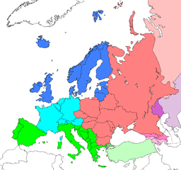
Map: Europe (location), subregions as delineated by United Nations geographic classification scheme:
- Asian portions of these countries
- Asian portions of these countries
Countries of Central Asia with partial territory in Eastern Europe – Kazakhstan
- Asian portions of these countries
Siū-khoân
| 此作品已由其作者,Electionworld,釋出至公有領域。此授權條款在全世界均適用。 這可能在某些國家不合法,如果是的話: |
原始上傳日誌
| date/time | username | resolution | size | edit summary |
|---|---|---|---|---|
| 16:25, 10 June 2008 | User:Milosevo | 984×924 | 50 KB | STOP VANDALISING! KOSOVO ISN'T A UN MEMBER, SO KOSOVO CAN'T BE IN A UN SUBREGION! |
| 13:28, 10 June 2008 | User:Cradel | 638×599 | 166 KB | Reverted to version as of 20:44, 9 June 2008jere |
| 12:07, 10 June 2008 | User:Milosevo | 984×924 | 50 KB | Reverted, again: kosovo isn't UN member, so it can't be in an UN subregion. |
| 20:44, 9 June 2008 | User:Cradel | 638×599 | 166 KB | Reverted to version as of 20:16, 8 June 2008 |
| 14:15, 9 June 2008 | User:Milosevo | 984×924 | 50 KB | kosovo isn't a UN member, so it can't be in an UN subregion. |
| 20:16, 8 June 2008 | User:Cradel | 638×599 | 166 KB | Reverted to version as of 18:17, 1 May 2008 |
| 10:17, 8 June 2008 | User:Milosevo | 984×924 | 50 KB | Reverted to version as of 23:06, 30 April 2008 |
| 18:17, 1 May 2008 | User:Cradel | 638×599 | 166 KB | Reverted vandalism |
| 23:06, 30 April 2008 | User:Serbish | 984×924 | 50 KB | Reverted to version as of 23:01, 29 January 2008 |
| 20:53, 7 April 2008 | User:Cradel | 638×599 | 166 KB | + Kosovo |
| 23:01, 29 January 2008 | User:Mahahahaneapneap | 984×924 | 50 KB | pngcrushed |
| 14:46, 3 December 2006 | User:Electionworld | 984×924 | 73 KB | {{ew|en|Cogito ergo sumo}} Map: <a href="https://www.how.com.vn/wiki/zh-min-nan/Europe" class="mw-redirect" title="Europe">Europe</a> (location), <a href="https://www.how.com.vn/wiki/?lang=zh-min-nan&title=Subregion&action=edit&redlink=1" class="new" rel="nofollow" target="_blank" title="Subregion (page does not exist)">subregions</a> as delineated by [http://unstats.un.org/unsd/methods/m49/m49regin.htm United Nations geographic classification scheme]:<br> {{legend|#4080FF|<a href="https://www.how.com.vn/wiki/?lang=zh-min-nan&title=Northern_Europe&action=edit&redlink=1" class="new" rel="nofollow" target="_blank" title="Northern Europe (page does not exist)">Northern Europe</a>}} {{legend|#00FFFF|[[Wes |
Tóng-àn le̍k-sú
Chhi̍h ji̍t-kî/sî-kan, khoàⁿ hit sî-chūn--ê tóng-àn.
| Ji̍t-kî/Sî-kan | 細張圖 | 寸尺 | Iōng-chiá | Chù-kái | |
|---|---|---|---|---|---|
| hiān-chāi | 2008-nî 8-goe̍h 8-ji̍t (pài-gō·) 15:17 | | 984 × 924(50 KB) | BetacommandBot | move approved by: User:Samulili This image was moved from Image:Location-Europe-UNsubregions.png {{ew|en|Cogito ergo sumo}} Map: Europe (location), subregions as delineated by [http://unstats.un.org/unsd/methods/m49/m49regin.htm United |
Iáⁿ-siōng liân-kiat
Í-hā ê ia̍h liân kàu chit ê iáⁿ-siōng:
tóng-àn hō͘ lâng sái--ê chōng-hóng
Ē-kha--ê kî-thaⁿ wiki ēng tio̍h chit--ê tóng-àn:
- ace.wikipedia.org hō͘ lâng ēng--ê chêng-hêng
- af.wikipedia.org hō͘ lâng ēng--ê chêng-hêng
- ar.wikipedia.org hō͘ lâng ēng--ê chêng-hêng
- be-tarask.wikipedia.org hō͘ lâng ēng--ê chêng-hêng
- be.wikipedia.org hō͘ lâng ēng--ê chêng-hêng
- bg.wikipedia.org hō͘ lâng ēng--ê chêng-hêng
- bn.wikipedia.org hō͘ lâng ēng--ê chêng-hêng
- br.wikipedia.org hō͘ lâng ēng--ê chêng-hêng
- bs.wikipedia.org hō͘ lâng ēng--ê chêng-hêng
- ceb.wikipedia.org hō͘ lâng ēng--ê chêng-hêng
- crh.wikipedia.org hō͘ lâng ēng--ê chêng-hêng
- cy.wikipedia.org hō͘ lâng ēng--ê chêng-hêng
- da.wikipedia.org hō͘ lâng ēng--ê chêng-hêng
- en.wikipedia.org hō͘ lâng ēng--ê chêng-hêng
- en.wikivoyage.org hō͘ lâng ēng--ê chêng-hêng
- eo.wikipedia.org hō͘ lâng ēng--ê chêng-hêng
- eu.wikipedia.org hō͘ lâng ēng--ê chêng-hêng
- fa.wikipedia.org hō͘ lâng ēng--ê chêng-hêng
- fi.wikipedia.org hō͘ lâng ēng--ê chêng-hêng
- fr.wikipedia.org hō͘ lâng ēng--ê chêng-hêng
- fy.wikipedia.org hō͘ lâng ēng--ê chêng-hêng
- fy.wiktionary.org hō͘ lâng ēng--ê chêng-hêng
- gag.wikipedia.org hō͘ lâng ēng--ê chêng-hêng
- gd.wikipedia.org hō͘ lâng ēng--ê chêng-hêng
- gl.wikipedia.org hō͘ lâng ēng--ê chêng-hêng
- id.wikipedia.org hō͘ lâng ēng--ê chêng-hêng
- io.wikipedia.org hō͘ lâng ēng--ê chêng-hêng
檢視此檔案的更多全域使用狀況。
🔥 Top keywords: Thâu-ia̍hCarles PuigdemontTē-jī-chhù Sè-kài Tāi-chiànTek-pia̍t:尋討Wiki HowWikipedia:Chhiū-á-khaPang-chān:Bo̍k-lio̍kEdgeworth (Pennsylvania)Bân-lâm-gúWikipedia:It-poaⁿ ê seng-bêngIōng-chiá thó-lūn:Ndgf741Wikipedia:Siā-lí mn̂g-chhùi-kháuWikipedia:Bián-chek seng-bêngThó-lūn:Thâu-ia̍hSin-bûn sū-kiāⁿSam-tho̍k-hōeTek-pia̍t:最近其改變TorPortal:Sin-bûn sū-kiāⁿWikipedia:Hoan-gêng sin iōng-chiáWikipedia:Tāi-sài-koánKennedy Thài-khong Tiong-simTâi-oân ê ki-pún kang-chuPang-chān:新手入門Pang-chān:Pian-chi̍p640 nîLūi-pia̍t:Seng-bu̍t-ha̍kÌn-nîRutracker.orgWikipedia:Hoan-gêngBí-kok8 goe̍h 25 ji̍tBBC World ServiceTek-pia̍t:我其討論tóng-àn:Incubator-logo.svg1992 nî Hā-kùi Olympic Ūn-tōng-hoēChū-iû lōe-iông1883 nî kiàn-tio̍k800 nî