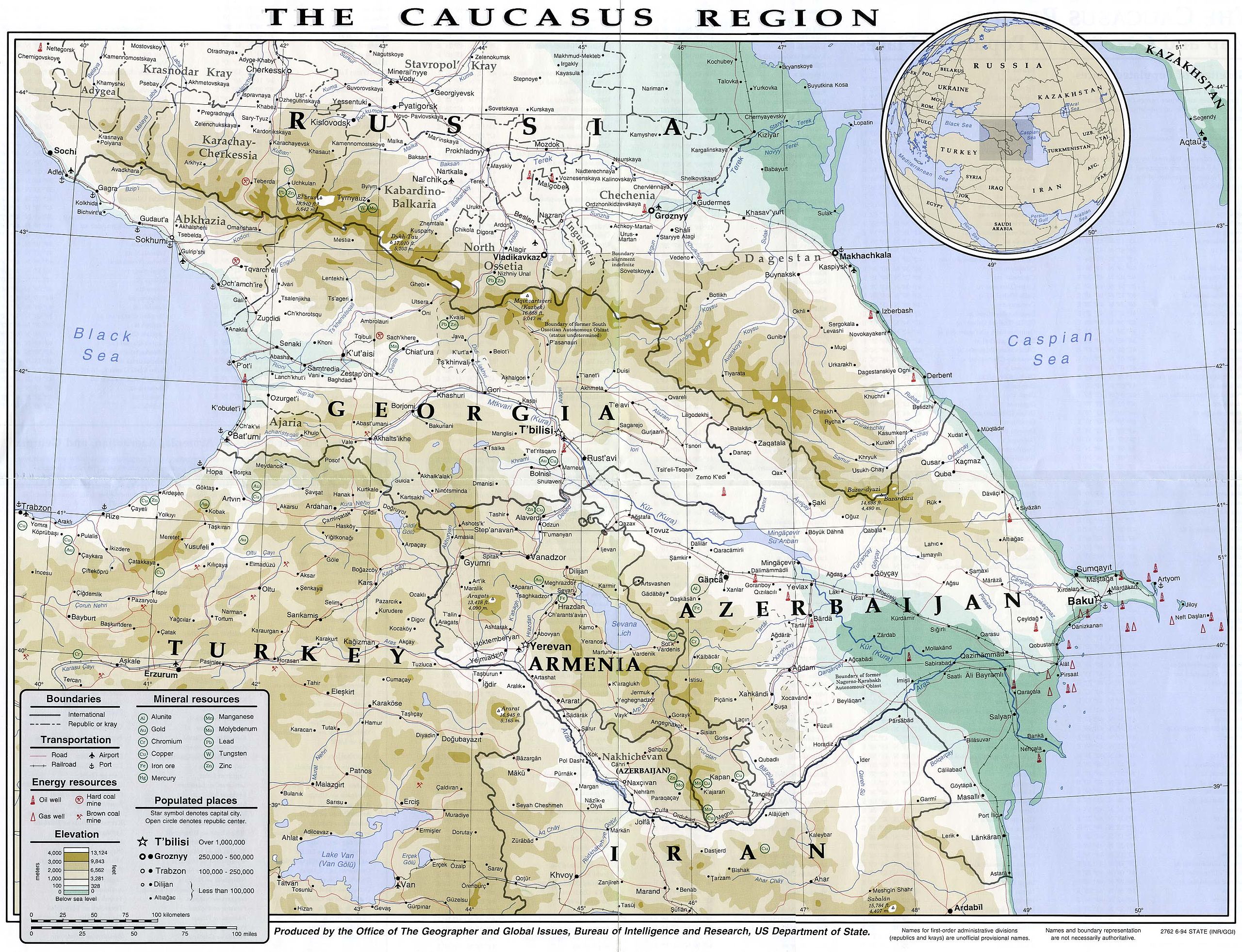
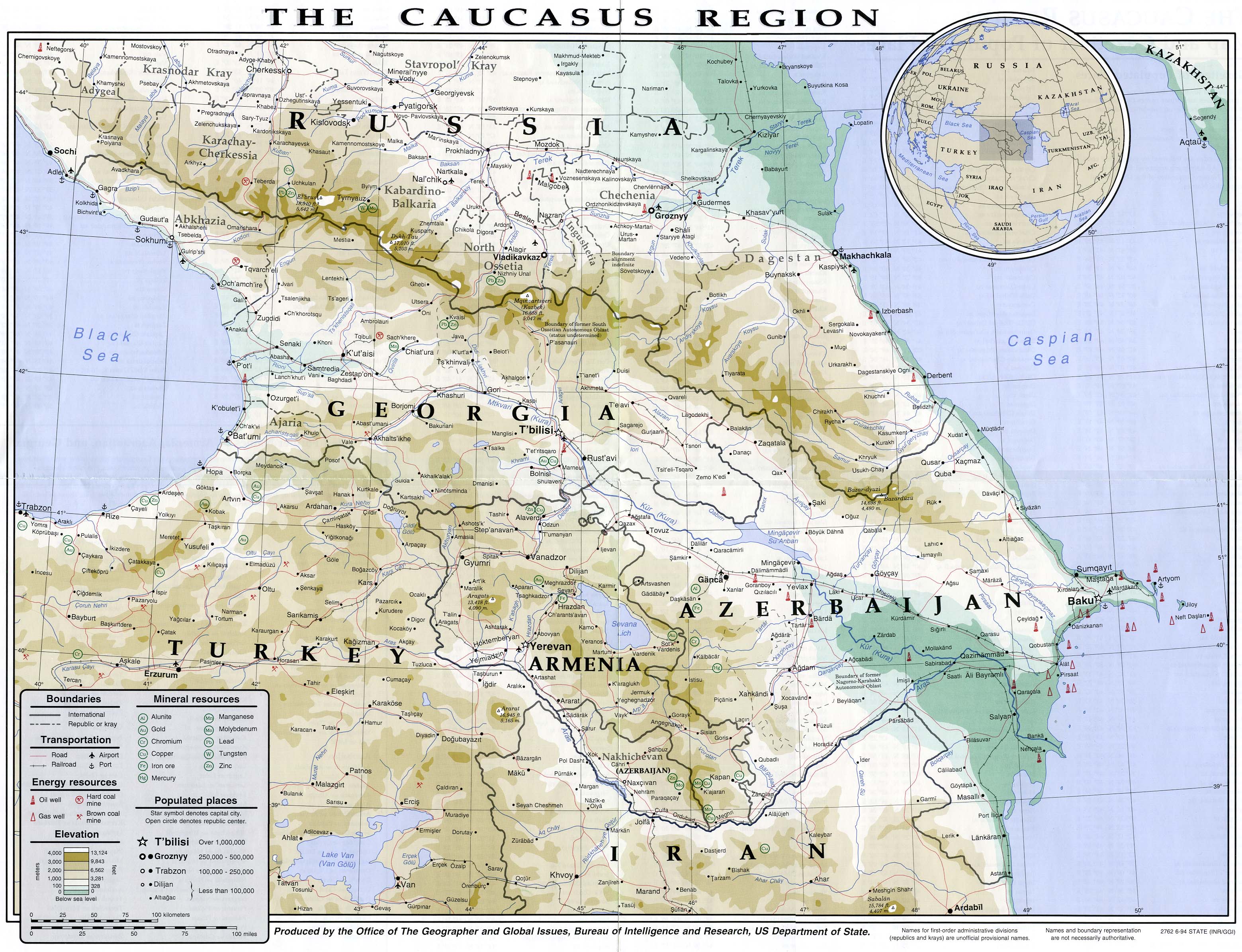
Gambar:Caucasus region 1994.jpg

Ukuran ieu pramidang: 782 × 600 pixel. Resolusi lianna: 313 × 240 pixel | 626 × 480 pixel | 1.002 × 768 pixel | 1.280 × 982 pixel | 2.560 × 1.963 pixel | 3.119 × 2.392 pixel.
Berkas asli (3.119 × 2.392 piksel, ukuran koropak: 1,18 MB, tipeu MIME: image/jpeg)
| Berkas ieu asalna ti Wikimedia Commons. Kaca ngeunaan katerangan berkas ieu di Commons aya disalin di handap. Commons téh hiji gudang berkas bébas nu eusina disumbang ku balaréa. |
| Pedaran | English: Map of the Caucasus region in 1994 Français : Carte du Caucase en 1994 | |||
| Titimangsa | ||||
| Sumber | University of Texas Library | |||
| Pangarang | CIA | |||
| Widi (Migunakeun deui ieu berkas) |
| |||
| Versi lainnya |


Jujutan berkas
Klik dina titimangsa pikeun nempo koropak nu aya dina mangsa éta.
| Titimangsa | Miniatur | Ukuran | Pamaké | Kamandang | |
|---|---|---|---|---|---|
| kiwari | 16 Juli 2007 14.49 | | 3.119 × 2.392 (1,18 MB) | Pmx | {{Information |Description= {{en|Map of the Caucasus region in 1994}} {{fr|Carte du Caucase en 1994}} |Source=University of Texas Library [http://www.lib.utexas.edu/maps/commonwealth/caucasus_region_1994.jpg] |Date=1994 |Author=CIA |Permission=Public doma |
Pamakéan berkas
Ieu berkas dipaké ku kaca di handap:
Pamakéan berkas sajagat
Wiki lianna anu maké ieu berkas:
- Pamakéan di ar.wikipedia.org
- Pamakéan di arz.wikipedia.org
- Pamakéan di ast.wikipedia.org
- Pamakéan di azb.wikipedia.org
- Pamakéan di az.wikipedia.org
- Pamakéan di ba.wikipedia.org
- Pamakéan di bg.wikipedia.org
- Pamakéan di bh.wikipedia.org
- Pamakéan di bs.wikipedia.org
- Pamakéan di ca.wikipedia.org
- Pamakéan di de.wikivoyage.org
- Pamakéan di en.wikipedia.org
- Pamakéan di eo.wikipedia.org
- Pamakéan di eu.wikipedia.org
- Pamakéan di fr.wikipedia.org
- Pamakéan di ga.wikipedia.org
- Pamakéan di he.wikipedia.org
- Pamakéan di hif.wikipedia.org
- Pamakéan di hr.wikipedia.org
- Pamakéan di hu.wikipedia.org
- Pamakéan di id.wikipedia.org
- Pamakéan di it.wikipedia.org
- Pamakéan di it.wikivoyage.org
- Pamakéan di kk.wikipedia.org
- Pamakéan di ko.wikipedia.org
- Pamakéan di ku.wikipedia.org
- Pamakéan di ml.wikipedia.org
- Pamakéan di ms.wikipedia.org
- Pamakéan di pnb.wikipedia.org
- Pamakéan di pt.wikipedia.org
- Pamakéan di ro.wikipedia.org
- Pamakéan di sl.wikipedia.org
- Pamakéan di so.wikipedia.org
- Pamakéan di sv.wikivoyage.org
- Pamakéan di ta.wikipedia.org
- Pamakéan di tg.wikipedia.org
- Pamakéan di th.wikipedia.org
- Pamakéan di tl.wikipedia.org
Témbongkeun pamakéan global leuwih loba pikeun ieu berkas.
Métadata
🔥 Top keywords: