Tiwi, officially the Municipality of Tiwi (Central Bikol: Banwaan kan Tiwi; Tagalog: Bayan ng Tiwi) is a 1st class municipality in the Province of Albay, Philippines. According to the 2020 census, it has a population of 56,444 people.[3]
Tiwi | |
|---|---|
| Municipality of Tiwi | |
 Tiwi Church | |
 Flag | |
 Map of Albay with Tiwi highlighted | |
OpenStreetMap  | |
.svg) Tiwi Location within the Philippines | |
| Coordinates: 13°27′31″N 123°40′50″E / 13.4585°N 123.6805°E | |
| Country | Philippines |
| Region | Bicol Region |
| Province | Albay |
| District | 1st district |
| Founded | 1696 |
| Barangays | 25 (see Barangays) |
| Government | |
| • Type | Sangguniang Bayan |
| • Mayor | Jaime C. Villanueva |
| • Vice Mayor | David C. Beato |
| • Representative | Edcel C. Lagman |
| • Municipal Council | Members |
| • Electorate | 36,928 voters (2022) |
| Area | |
| • Total | 105.76 km2 (40.83 sq mi) |
| Elevation | 61 m (200 ft) |
| Highest elevation | 965 m (3,166 ft) |
| Lowest elevation | 0 m (0 ft) |
| Population (2020 census)[3] | |
| • Total | 56,444 |
| • Density | 530/km2 (1,400/sq mi) |
| • Households | 12,657 |
| Economy | |
| • Income class | 1st municipal income class |
| • Poverty incidence | 24.70 |
| • Revenue | ₱ 237.2 million (2020) |
| • Assets | ₱ 567.8 million (2020) |
| • Expenditure | ₱ 219.5 million (2020) |
| • Liabilities | ₱ 158 million (2020) |
| Service provider | |
| • Electricity | Albay Power and Energy Corporation (APEC) |
| Time zone | UTC+8 (PST) |
| ZIP code | 4513 |
| PSGC | |
| IDD : area code | +63 (0)52 |
| Native languages | Central Bikol Tagalog |
| Website | www |
Etymology
editFriars called the place Tigbi, which evolved into Tivi and, then, finally to its present name Tiwi.[5][6]
History
editTiwi began as a barrio of Malinao before it was formally organized as a politically independent pueblo in 1696. As a pueblo, it was governed by a gobernadorcillo. As a Catholic parish, it was administered by a secular priest under the then Diocese of Nueva Caceres, now an archdiocese. In its primeval stages, it had some 1,105 houses, a parish church, a community-funded primary school, and a cemetery outside the town proper. The villagers ordinarily engaged in fishing, planting rice, corn, sugarcane, indigo, fruit-bearing trees, and vegetables. Aside from agriculture, they also busied themselves weaving cotton and abaca clothes, and in pottery.[7]
In Kagnipa, known today as Barangay Baybay, stands the dilapidated Sinimbahan. It is the remnant of the first concrete house of worship built by the Franciscans led by the pastor of Malinao, Fray Pedro de Brosas, remains to be the deaf witness of both the villagers' ready acceptance of the Christian faith and their suffering of persecution at the hands of the Moslems; Christian missionaries called them Moros. The parola by the shore of Sitio Nipa of the same barangay testifies to the people's paralyzing fear of the Moros' capricious forays. The market site of the pueblo before these raids was located in the present location of Baybay Elementary School. In order to sidetrack surprise attacks, at least temporarily, the market site was transferred to southernmost part of now Barangay Baybay; henceforth, it was called Binanwaan. The transfer, however, was useless. Finally, to have enough time to escape and keep themselves safer from their enemies' easy attacks, the inhabitants moved the market site and their settlement to the present poblacion now named as Barangay Tigbi. Before the Moro's assaults, Barangay Baybay was then the center of trade and commerce because of its easy accessibility to marine transportation of goods. The goods came from the islands of what are now known as Catanduanes, San Miguel, Rapu-Rapu, and Batan, not to mention those from adjoining pueblos in the mainland of Ibalon, now the province of Albay, and the Camarines.[7]
In the extant records of the municipality, the first chief executive of the municipal government was Don Lorenzo Mancilla installed in 1776.
Geography
editTiwi is located at 13°27′31″N 123°40′50″E / 13.4585°N 123.6805°E.
According to the Philippine Statistics Authority, the municipality has a land area of 105.76 square kilometres (40.83 sq mi) [8] constituting 4.11% of the 2,575.77-square-kilometre- (994.51 sq mi) total area of Albay. Tiwi is 38 kilometres (24 mi) from Legazpi City and 565 kilometres (351 mi) from Manila.
Climate
edit| Climate data for Tiwi, Albay | |||||||||||||
|---|---|---|---|---|---|---|---|---|---|---|---|---|---|
| Month | Jan | Feb | Mar | Apr | May | Jun | Jul | Aug | Sep | Oct | Nov | Dec | Year |
| Mean daily maximum °C (°F) | 27 (81) | 27 (81) | 28 (82) | 30 (86) | 31 (88) | 30 (86) | 29 (84) | 29 (84) | 29 (84) | 29 (84) | 28 (82) | 27 (81) | 29 (84) |
| Mean daily minimum °C (°F) | 22 (72) | 22 (72) | 23 (73) | 24 (75) | 25 (77) | 25 (77) | 25 (77) | 25 (77) | 25 (77) | 24 (75) | 24 (75) | 23 (73) | 24 (75) |
| Average precipitation mm (inches) | 138 (5.4) | 83 (3.3) | 74 (2.9) | 50 (2.0) | 108 (4.3) | 165 (6.5) | 202 (8.0) | 165 (6.5) | 190 (7.5) | 186 (7.3) | 188 (7.4) | 183 (7.2) | 1,732 (68.3) |
| Average rainy days | 16.8 | 11.9 | 13.5 | 13.8 | 20.5 | 25.2 | 27.4 | 26.2 | 26.1 | 24.7 | 20.7 | 18.5 | 245.3 |
| Source: Meteoblue[9] | |||||||||||||
Barangays
editTiwi is politically subdivided into 25 barangays.[10] Each barangay consists of puroks and some have sitios.
| PSGC | Barangay | Population | ±% p.a. | |||
|---|---|---|---|---|---|---|
| 2020[3] | 2010[11] | |||||
| 050518001 | Bagumbayan | 4.1% | 2,315 | 2,148 | 0.75% | |
| 050518002 | Bariis | 1.9% | 1,092 | 921 | 1.72% | |
| 050518003 | Baybay | 4.0% | 2,265 | 2,207 | 0.26% | |
| 050518004 | Belen (Malabog) | 2.5% | 1,406 | 1,273 | 1.00% | |
| 050518005 | Biyong | 3.0% | 1,680 | 1,543 | 0.85% | |
| 050518006 | Bolo | 2.1% | 1,205 | 1,173 | 0.27% | |
| 050518007 | Cale | 9.8% | 5,557 | 5,245 | 0.58% | |
| 050518008 | Cararayan | 3.6% | 2,012 | 2,011 | 0.00% | |
| 050518009 | Coro-coro | 3.1% | 1,747 | 1,587 | 0.96% | |
| 050518010 | Dap-dap | 1.6% | 891 | 765 | 1.54% | |
| 050518011 | Gajo | 2.7% | 1,536 | 1,489 | 0.31% | |
| 050518012 | Joroan | 4.9% | 2,741 | 2,667 | 0.27% | |
| 050518013 | Libjo | 5.2% | 2,936 | 2,624 | 1.13% | |
| 050518014 | Libtong | 4.1% | 2,304 | 2,253 | 0.22% | |
| 050518017 | Matalibong | 2.5% | 1,397 | 1,290 | 0.80% | |
| 050518018 | Maynonong | 1.5% | 824 | 674 | 2.03% | |
| 050518019 | Mayong | 2.9% | 1,632 | 1,660 | −0.17% | |
| 050518020 | Misibis | 3.9% | 2,192 | 2,064 | 0.60% | |
| 050518021 | Naga | 8.2% | 4,629 | 4,614 | 0.03% | |
| 050518023 | Nagas | 5.7% | 3,206 | 2,925 | 0.92% | |
| 050518024 | Oyama | 2.3% | 1,289 | 1,208 | 0.65% | |
| 050518025 | Putsan | 2.2% | 1,234 | 1,186 | 0.40% | |
| 050518026 | San Bernardo | 3.1% | 1,759 | 1,530 | 1.40% | |
| 050518027 | Sogod | 3.7% | 2,103 | 1,993 | 0.54% | |
| 050518028 | Tigbi (Poblacion) | 5.6% | 3,168 | 3,113 | 0.18% | |
| Total | 56,444 | 50,163 | 1.19% | |||
Lourdes is another Barangay in the Municipality of Tiwi, Albay.
Demographics
edit| Year | Pop. | ±% p.a. |
|---|---|---|
| 1903 | 9,593 | — |
| 1918 | 10,557 | +0.64% |
| 1939 | 12,539 | +0.82% |
| 1948 | 14,350 | +1.51% |
| 1960 | 17,691 | +1.76% |
| 1970 | 22,037 | +2.22% |
| 1975 | 24,350 | +2.02% |
| 1980 | 28,726 | +3.36% |
| 1990 | 34,658 | +1.90% |
| 1995 | 39,733 | +2.59% |
| 2000 | 44,261 | +2.34% |
| 2007 | 49,185 | +1.47% |
| 2010 | 50,163 | +0.72% |
| 2015 | 53,120 | +1.10% |
| 2020 | 56,444 | +1.20% |
| Source: Philippine Statistics Authority[12][11][13][14] | ||
In the 2020 census, Tiwi had a population of 56,444.[3] The population density was 530 inhabitants per square kilometre (1,400/sq mi).
Religion
editRoman Catholicism remained the dominant religion since its propagation in the town 1696.
Language
editGenerally the town speaks Central Bikol as their first language while others speak Buhinon in the areas near Buhi, Camarines Sur. Other Bikol languages are spoken by significant minorities that are from other areas of the Bicol Region.[citation needed]
The majority of the inhabitants also understand Tagalog (Filipino) and English as second languages.
Economy
editPoverty incidence of Tiwi
10 20 30 40 2006 38.10 2009 37.85 2012 27.41 2015 27.87 2018 23.58 2021 24.70 Source: Philippine Statistics Authority[15][16][17][18][19][20][21][22] |
Tourism
edit- Parish Church of Our Lady of Salvation, Barangay Joroan
- Parish Church of St. Lawrence, Deacon & Martyr, Barangay Tigbi
- Tiwi Hot Springs Resorts/Mendoza & Mirasol Resorts - Barangay Naga
- Corangon Shoal, Barangay Baybay
- PhilCeramics, Barangay Putsan
- Naglagbong Park and Science Centrum Museum, Barangay Naga
- Rangasa Spring Resort
- Sinimbahan Ruins, Barangay Baybay[23]
- Japanese Garden, Barangay Tigbi
- Bugsukan Falls, Barangay Misibis
- Baybay-Bolo Beach
- Sogod Beach
- Maslog Waterfalls, Barangay Misibis
- Tiwi Geothermal Power Plant
- DJC Halo-Halo
- Capantagan Waterfalls, Barangay Cale
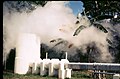 Tiwi Geothermal Plant
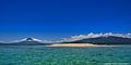
 Joroan Beach


