Muzaffarabad (/ˌmʊzəˌfærəˈbæd/;[5] Urdu: مُظَفَّر آباد, IPA: [mʊzəffərɑːbɑːd]) is a city in Pakistani-administered Azad Kashmir in the disputed Kashmir region.[1] It is the largest city and the capital of Azad Kashmir, which is a Pakistani-administered administrative territory.
Muzaffarabad مظفر آباد | |
|---|---|
City administered by Pakistan | |
 | |
 Interactive map of Muzaffarabad | |
![A map showing Pakistan-administered Azad Kashmir shaded in sage in the disputed Kashmir region[1]](https://www.how.com.vn/wiki/en/File:Kashmir_region._LOC_2003626427_-_showing_sub-regions_administered_by_different_countries.jpg) | |
| Coordinates: 34°21′30″N 73°28′20″E / 34.35833°N 73.47222°E | |
| Administering country | Pakistan |
| Territory | Azad Kashmir |
| District | Muzaffarabad |
| Founded by | Sultan Muzaffar Khan |
| Government | |
| • Mayor | Sikandar Gilani (PML(N)) |
| • Deputy Mayor | Khalid Awan (PPP) |
| • Deputy Commissioner | Tahir Mumtaz BPS-18(PAS) |
| • District Police Officer | Mirza Zahid Hussain BPS-18(PSP) |
| Elevation | 737 m (2,418 ft) |
| Population | |
| • City | 149,913 |
| • Rank | 60th, Pakistan |
| Languages | |
| • Official | Urdu[3][4][note 1] |
| • Spoken | |
| Time zone | UTC+05:00 (PST) |
| Calling code | 05822 |
| Website | Muzaffarabad Government Portal (defunct) |
The city is located in Muzaffarabad District, near the confluence of the Jhelum and Neelum rivers. The district is bounded by the Pakistani province of Khyber Pakhtunkhwa in the west, the Kupwara and Baramulla districts of Indian-administered Jammu and Kashmir in the east, and the Neelum District in the north.
History
Muzaffarabad was founded in 1646 by Sultan Muzaffar Khan, chief of the Bomba tribe[6] who ruled Kashmir.[7] Khan also constructed the Red Fort that same year for the purpose of warding off incursions from the Mughal Empire.
2005 earthquake
The city was near the epicenter of the 2005 Kashmir earthquake, which had a magnitude of 7.6 Mw. The earthquake destroyed about 50 percent of the buildings in the city (including most government buildings) and is estimated to have killed up to 80,000 people in the Pakistani-controlled areas. As of 8 October 2005[update], the Pakistani government's official death toll was 87,350, while other estimates have put the death toll at over 100,000.[8]
Administrative subdivisions

The district of Muzaffarabad is administratively divided into 2 tehsils, which are subdivided into 25 union councils.[9]
- Muzaffarabad
- Pattika (Naseerabad)
Climate
| Climate data for Muzaffarabad (1961–2009) | |||||||||||||
|---|---|---|---|---|---|---|---|---|---|---|---|---|---|
| Month | Jan | Feb | Mar | Apr | May | Jun | Jul | Aug | Sep | Oct | Nov | Dec | Year |
| Record high °C (°F) | 27.0 (80.6) | 29.4 (84.9) | 37.0 (98.6) | 40.5 (104.9) | 46.5 (115.7) | 46.2 (115.2) | 45.0 (113.0) | 40.2 (104.4) | 39.0 (102.2) | 38.3 (100.9) | 33.0 (91.4) | 27.0 (80.6) | 46.5 (115.7) |
| Mean daily maximum °C (°F) | 16.0 (60.8) | 18.0 (64.4) | 22.6 (72.7) | 28.3 (82.9) | 33.5 (92.3) | 37.4 (99.3) | 34.9 (94.8) | 34.0 (93.2) | 33.4 (92.1) | 30.1 (86.2) | 24.2 (75.6) | 18.1 (64.6) | 22.3 (72.1) |
| Mean daily minimum °C (°F) | 3.1 (37.6) | 5.4 (41.7) | 9.7 (49.5) | 14.2 (57.6) | 18.4 (65.1) | 21.9 (71.4) | 22.8 (73.0) | 22.6 (72.7) | 19.4 (66.9) | 13.7 (56.7) | 7.8 (46.0) | 4.1 (39.4) | 11.1 (52.0) |
| Record low °C (°F) | −3.0 (26.6) | −1.1 (30.0) | 1.0 (33.8) | 6.5 (43.7) | 7.0 (44.6) | 12.0 (53.6) | 15.5 (59.9) | 16.0 (60.8) | 12.4 (54.3) | 6.5 (43.7) | 1.0 (33.8) | −1.4 (29.5) | −3 (27) |
| Average rainfall mm (inches) | 101.3 (3.99) | 137.4 (5.41) | 157.3 (6.19) | 109.0 (4.29) | 78.5 (3.09) | 113.6 (4.47) | 328.7 (12.94) | 229.9 (9.05) | 112.6 (4.43) | 45.9 (1.81) | 37.2 (1.46) | 69.0 (2.72) | 1,242.8 (48.93) |
| Average relative humidity (%) (at 12:00 PST) | 50.3 | 46.3 | 40.9 | 38.0 | 33.2 | 34.0 | 52.2 | 57.6 | 48.1 | 42.4 | 48.4 | 54.0 | 37.2 |
| Source: Pakistan Meteorological Department[10] | |||||||||||||
Transport
This section needs expansion. You can help by adding to it. (June 2020) |
Muzaffarabad's public transportation system primarily relies on buses, rickshaws, and small pickup trucks for intracity travel. Following the devastating 2005 earthquake that severely damaged infrastructure, including roads, the city government, with international aid, rebuilt roads, bridges, and other essential infrastructure. However, public transportation remains underdeveloped. Notably, Muzaffarabad lacks a railway system and a functional airport. The nearest railway station is located in the Rawalpindi District of Pakistani Punjab.[11]
Notable people
- Anam Najam, medical doctor and psychiatrist[citation needed]
Gallery
 Heightened view of the city on both riverbanks after the 2005 Kashmir earthquake, c. 2014
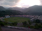 Photo of Muzaffarabad Cricket Stadium
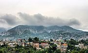 Photo of the city's skyline, c. 2017
 Azad Jammu Kashmir Medical College
 Muzaffarabad City, Azad Kashmir, Pakistan


See also
Notes
- ^ Snedden (2013, p. 176): On p. 29, the census report states that Urdu is the official language of the government of Azad Kashmir, with Kashmiri, Pahari, Gojri, Punjabi, Kohistani, Pushto, and Sheena 'frequently spoken in Azad Kashmir'. Yet, when surveyed about their 'mother tongue', Azad Kashmiris' choices were limited to selecting from Pakistan's major languages: Urdu, Punjabi, Sindhi, Pushto, Balochi, Saraiki, and 'others'; not surprisingly, 2.18 million of Azad Kashmir's 2.97 million people chose 'others'.
References
Sources
- Rahman, Tariq (1996). Language and politics in Pakistan. Oxford University Press. ISBN 978-0-19-577692-8.
- Snedden, Christopher (2013) [first published as The Untold Story of the People of Azad Kashmir, 2012]. Kashmir: The Unwritten History. HarperCollins India. ISBN 978-9350298985.