Sonora is a state in Northwestern Mexico that is divided into 72 municipalities. According to the 2020 Mexican census, it is the eighteenth most populated state with 2,944,840 inhabitants and the 2nd largest by land area spanning 179,354.7 square kilometres (69,249.2 sq mi).[1][2]
.svg)
Municipalities in Sonora are administratively autonomous of the state according to the 115th article of the 1917 Constitution of Mexico.[3] Every three years, citizens elect a municipal president (Spanish: presidente municipal) by a plurality voting system who heads a concurrently elected municipal council (ayuntamiento) responsible for providing all the public services for their constituents. The municipal council consists of a variable number of trustees and councillors (regidores y síndicos).[4] Municipalities are responsible for public services (such as water and sewerage), street lighting, public safety, traffic, and the maintenance of public parks, gardens and cemeteries.[5] They may also assist the state and federal governments in education, emergency fire and medical services, environmental protection and maintenance of monuments and historical landmarks. Since 1984, they have had the power to collect property taxes and user fees, although more funds are obtained from the state and federal governments than from their own income.[5]
The largest municipality by population is Hermosillo, with 936,263 residents (31.79% of the state's total), while the smallest is Onavas with 365 residents.[1] The largest municipality by land area is also Hermosillo which spans 15,724.30 km2 (6,071.19 sq mi), and the smallest is San Felipe de Jesús with 151.30 km2 (58.42 sq mi).[2] The newest municipalities are Benito Juárez and San Ignacio Río Muerto, established in 1996.[6]
Municipalities edit
- Largest municipalities in Sonora by population
 Hermosillo, capital and largest municipality by population in Sonora.
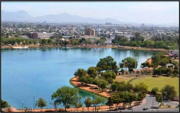 Cajeme, second largest municipality by population.
 Nogales, third largest municipality by population.


| Name | Municipal seat | Population (2020)[1] | Population (2010)[7] | Change | Land area[2] | Population density (2020) | Incorporation date[6] | |
|---|---|---|---|---|---|---|---|---|
| km2 | sq mi | |||||||
| Aconchi[a] | Aconchi | 2,563 | 2,637 | −2.8% | 368.2 | 142.2 | 7.0/km2 (18.0/sq mi) | December 26, 1829 |
| Agua Prieta | Agua Prieta | 91,929 | 79,138 | +16.2% | 3,946.5 | 1,523.8 | 23.3/km2 (60.3/sq mi) | August 28, 1916 |
| Álamos | Álamos | 24,976 | 25,848 | −3.4% | 6,422.8 | 2,479.9 | 3.9/km2 (10.1/sq mi) | January 19, 1825 |
| Altar[b] | Altar | 9,492 | 9,049 | +4.9% | 4,457.7 | 1,721.1 | 2.1/km2 (5.5/sq mi) | November 2, 1825 |
| Arivechi | Arivechi | 1,177 | 1,253 | −6.1% | 726.3 | 280.4 | 1.6/km2 (4.2/sq mi) | December 3, 1862 |
| Arizpe | Arizpe | 2,788 | 3,037 | −8.2% | 3,072.0 | 1,186.1 | 0.9/km2 (2.4/sq mi) | November 2, 1825 |
| Atil | Atil | 626 | 625 | +0.2% | 300.4 | 116.0 | 2.1/km2 (5.4/sq mi) | December 3, 1862 |
| Bacadéhuachi[c] | Bacadéhuachi | 979 | 1,252 | −21.8% | 1,066.0 | 411.6 | 0.9/km2 (2.4/sq mi) | December 3, 1862 |
| Bacanora[d] | Bacanora | 759 | 784 | −3.2% | 1,128.9 | 435.9 | 0.7/km2 (1.7/sq mi) | December 3, 1862 |
| Bacerac | Bacerac | 1,221 | 1,467 | −16.8% | 1,344.6 | 519.2 | 0.9/km2 (2.4/sq mi) | December 3, 1862 |
| Bacoachi | Bacoachi | 1,475 | 1,646 | −10.4% | 1,231.0 | 475.3 | 1.2/km2 (3.1/sq mi) | December 3, 1862 |
| Bácum[e] | Bácum | 23,151 | 22,821 | +1.4% | 1,583.3 | 611.3 | 14.6/km2 (37.9/sq mi) | August 31, 1911 |
| Banámichi[f] | Banámichi | 1,825 | 1,646 | +10.9% | 808.1 | 312.0 | 2.3/km2 (5.8/sq mi) | December 26, 1829 |
| Baviácora[g] | Baviácora | 3,191 | 3,560 | −10.4% | 842.5 | 325.3 | 3.8/km2 (9.8/sq mi) | December 26, 1829 |
| Bavispe[h] | Bavispe | 1,169 | 1,454 | −19.6% | 1,721.7 | 664.8 | 0.7/km2 (1.8/sq mi) | December 3, 1862 |
| Benito Juárez | Villa Juárez | 21,692 | 22,009 | −1.4% | 369.5 | 142.7 | 58.7/km2 (152.0/sq mi) | December 26, 1996 |
| Benjamín Hill | Benjamín Hill | 4,988 | 5,275 | −5.4% | 1,412.2 | 545.3 | 3.5/km2 (9.1/sq mi) | April 19, 1952 |
| Caborca | Caborca | 89,122 | 81,309 | +9.6% | 10,671.7 | 4,120.4 | 8.4/km2 (21.6/sq mi) | December 3, 1862 |
| Cajeme | Ciudad Obregón | 436,484 | 409,310 | +6.6% | 4,876.3 | 1,882.7 | 89.5/km2 (231.8/sq mi) | November 30, 1927 |
| Cananea | Cananea | 39,451 | 32,936 | +19.8% | 2,316.2 | 894.3 | 17.0/km2 (44.1/sq mi) | November 1, 1907 |
| Carbó[i] | Carbó | 4,946 | 5,347 | −7.5% | 2,581.8 | 996.8 | 1.9/km2 (5.0/sq mi) | July 3, 1943 |
| Cucurpe[j] | Cucurpe | 863 | 958 | −9.9% | 1,577.9 | 609.2 | 0.5/km2 (1.4/sq mi) | December 3, 1862 |
| Cumpas | Cumpas | 5,829 | 6,362 | −8.4% | 2,010.0 | 776.1 | 2.9/km2 (7.5/sq mi) | December 3, 1862 |
| Divisaderos | Divisaderos | 753 | 813 | −7.4% | 385.7 | 148.9 | 2.0/km2 (5.1/sq mi) | April 23, 1932 |
| Empalme[k] | Empalme | 51,431 | 54,131 | −5.0% | 593.2 | 229.0 | 86.7/km2 (224.6/sq mi) | May 8, 1937 |
| Etchojoa | Etchojoa | 61,309 | 60,717 | +1.0% | 948.6 | 366.3 | 64.6/km2 (167.4/sq mi) | October 15, 1909 |
| Fronteras[l] | Fronteras | 9,041 | 8,639 | +4.7% | 2,616.4 | 1,010.2 | 3.5/km2 (8.9/sq mi) | December 3, 1862 |
| Granados[m] | Granados | 1,009 | 1,150 | −12.3% | 363.9 | 140.5 | 2.8/km2 (7.2/sq mi) | December 3, 1862 |
| Guaymas[n] | Guaymas | 156,863 | 149,299 | +5.1% | 7,945.6 | 3,067.8 | 19.7/km2 (51.1/sq mi) | February 28, 1845 |
| Hermosillo[o] | Hermosillo† | 936,263 | 784,342 | +19.4% | 15,724.3 | 6,071.2 | 59.5/km2 (154.2/sq mi) | February 28, 1845 |
| Huachinera[p] | Huachinera | 1,186 | 1,350 | −12.1% | 1,197.6 | 462.4 | 1.0/km2 (2.6/sq mi) | December 15, 1921 |
| Huásabas[q] | Huásabas | 888 | 962 | −7.7% | 821.7 | 317.3 | 1.1/km2 (2.8/sq mi) | December 3, 1862 |
| Huatabampo | Huatabampo | 77,682 | 79,313 | −2.1% | 1,905.5 | 735.7 | 40.8/km2 (105.6/sq mi) | December 12, 1898 |
| Huépac[r] | Huépac | 943 | 1,154 | −18.3% | 420.8 | 162.5 | 2.2/km2 (5.8/sq mi) | December 3, 1862 |
| Imuris[s] | Imuris | 12,536 | 12,316 | +1.8% | 2,170.0 | 837.8 | 5.8/km2 (15.0/sq mi) | December 3, 1862 |
| La Colorada[t] | La Colorada | 1,848 | 1,663 | +11.1% | 4,122.1 | 1,591.6 | 0.4/km2 (1.2/sq mi) | June 26, 1889 |
| Magdalena | Magdalena de Kino | 33,049 | 29,707 | +11.2% | 1,239.4 | 478.5 | 26.7/km2 (69.1/sq mi) | December 3, 1862 |
| Mazatán [u] | Mazatán | 1,101 | 1,350 | −18.4% | 683.0 | 263.7 | 1.6/km2 (4.2/sq mi) | December 16, 1907 |
| Moctezuma[v] | Moctezuma | 5,173 | 4,680 | +10.5% | 1,877.5 | 724.9 | 2.8/km2 (7.1/sq mi) | November 2, 1825 |
| Naco | Naco | 5,774 | 6,401 | −9.8% | 1,238.4 | 478.1 | 4.7/km2 (12.1/sq mi) | June 30, 1937 |
| Nácori Chico[w] | Nácori Chico | 1,531 | 2,051 | −25.4% | 2,832.7 | 1,093.7 | 0.5/km2 (1.4/sq mi) | February 21, 1917 |
| Nacozari | Nacozari de García | 14,369 | 12,751 | +12.7% | 1,735.8 | 670.2 | 8.3/km2 (21.4/sq mi) | October 15, 1912 |
| Navojoa | Navojoa | 164,387 | 157,729 | +4.2% | 2,808.7 | 1,084.4 | 58.5/km2 (151.6/sq mi) | December 3, 1862 |
| Nogales | Nogales | 264,782 | 220,292 | +20.2% | 1,756.6 | 678.2 | 150.7/km2 (390.4/sq mi) | July 11, 1884 |
| Onavas[x] | Onavas | 365 | 399 | −8.5% | 534.2 | 206.3 | 0.7/km2 (1.8/sq mi) | December 3, 1862 |
| Opodepe[y] | Opodepe | 2,438 | 2,878 | −15.3% | 2,224.3 | 858.8 | 1.1/km2 (2.8/sq mi) | December 3, 1862 |
| Oquitoa[z] | Oquitoa | 496 | 443 | +12.0% | 916.4 | 353.8 | 0.5/km2 (1.4/sq mi) | December 3, 1862 |
| Pitiquito | Pitiquito | 9,122 | 9,468 | −3.7% | 9,820.0 | 3,791.5 | 0.9/km2 (2.4/sq mi) | December 3, 1862 |
| Puerto Peñasco | Puerto Peñasco | 62,689 | 57,342 | +9.3% | 6,193.3 | 2,391.2 | 10.1/km2 (26.2/sq mi) | July 7, 1952 |
| Plutarco Elías Calles | Sonoyta | 13,627 | 15,625 | −12.8% | 3,656.7 | 1,411.9 | 3.7/km2 (9.7/sq mi) | August 21, 1989 |
| Quiriego[aa] | Quiriego | 3,090 | 3,356 | −7.9% | 3,780.6 | 1,459.7 | 0.8/km2 (2.1/sq mi) | December 3, 1862 |
| Rayón[ab] | Rayón | 1,496 | 1,599 | −6.4% | 879.1 | 339.4 | 1.7/km2 (4.4/sq mi) | February 17, 1828 |
| Rosario | Rosario de Tesopaco | 4,830 | 5,226 | −7.6% | 3,519.8 | 1,359.0 | 1.4/km2 (3.6/sq mi) | November 2, 1825 |
| Sahuaripa[ac] | Sahuaripa | 5,257 | 6,020 | −12.7% | 5,003.8 | 1,932.0 | 1.1/km2 (2.7/sq mi) | November 2, 1825 |
| San Felipe de Jesús[ad] | San Felipe de Jesús | 369 | 396 | −6.8% | 151.3 | 58.4 | 2.4/km2 (6.3/sq mi) | December 3, 1862 |
| San Ignacio Río Muerto | San Ignacio Río Muerto | 14,279 | 14,136 | +1.0% | 1,383.6 | 534.2 | 10.3/km2 (26.7/sq mi) | December 26, 1996 |
| San Javier[ae] | San Javier | 537 | 492 | +9.1% | 535.9 | 206.9 | 1.0/km2 (2.6/sq mi) | December 3, 1862 |
| San Luis Río Colorado | San Luis Río Colorado | 199,021 | 178,380 | +11.6% | 8,860.0 | 3,420.9 | 22.5/km2 (58.2/sq mi) | July 1, 1939 |
| San Miguel de Horcasitas [af] | San Miguel de Horcasitas | 10,729 | 8,382 | +28.0% | 1,115.6 | 430.7 | 9.6/km2 (24.9/sq mi) | March 20, 1837 |
| San Pedro de la Cueva[ag] | San Pedro de la Cueva | 1,458 | 1,604 | −9.1% | 2,229.5 | 860.8 | 0.7/km2 (1.7/sq mi) | May 14, 1864 |
| Santa Ana | Santa Ana | 16,203 | 16,014 | +1.2% | 1,476.6 | 570.1 | 11.0/km2 (28.4/sq mi) | December 3, 1862 |
| Santa Cruz[ah] | Santa Cruz | 1,835 | 1,998 | −8.2% | 1,001.2 | 386.6 | 1.8/km2 (4.7/sq mi) | December 3, 1862 |
| Sáric[ai] | Sáric | 2,058 | 2,703 | −23.9% | 1,353.6 | 522.6 | 1.5/km2 (3.9/sq mi) | December 3, 1862 |
| Soyopa[aj] | Soyopa | 1,368 | 1,284 | +6.5% | 1,716.8 | 662.9 | 0.8/km2 (2.1/sq mi) | December 3, 1862 |
| Suaqui Grande[ak] | Suaqui Grande | 1,114 | 1,121 | −0.6% | 914.8 | 353.2 | 1.2/km2 (3.2/sq mi) | December 3, 1862 |
| Tepache[al] | Tepache | 1,178 | 1,365 | −13.7% | 778.7 | 300.7 | 1.5/km2 (3.9/sq mi) | December 3, 1862 |
| Trincheras[am] | Trincheras | 1,381 | 1,731 | −20.2% | 3,010.4 | 1,162.3 | 0.5/km2 (1.2/sq mi) | April 28, 1916 |
| Tubutama[an] | Tubutama | 1,473 | 1,735 | −15.1% | 1,725.4 | 666.2 | 0.9/km2 (2.2/sq mi) | December 3, 1862 |
| Ures | Ures | 8,548 | 9,185 | −6.9% | 3,088.1 | 1,192.3 | 2.8/km2 (7.2/sq mi) | May 13, 1848 |
| Villa Hidalgo[ao] | Villa Hidalgo | 1,429 | 1,738 | −17.8% | 1,471.5 | 568.1 | 1.0/km2 (2.5/sq mi) | December 11, 1874 |
| Villa Pesqueira[ap] | Villa Pesqueira | 1,043 | 1,254 | −16.8% | 1,123.2 | 433.7 | 0.9/km2 (2.4/sq mi) | May 6, 1852 |
| Yécora[aq] | Yécora | 4,793 | 6,046 | −20.7% | 2,667.7 | 1,030.0 | 1.8/km2 (4.7/sq mi) | December 3, 1862 |
| Sonora | — | 2,944,840 | 2,662,480 | +10.6% | 179,354.7 | 69,249.2 | 16.4/km2 (42.5/sq mi) | — |
| Mexico | — | 126,014,024 | 112,336,538 | +12.2% | 1,960,646.7 | 757,010 | 64.3/km2 (166.5/sq mi) | — |
Notes edit
- ^ Aconchi was merged with Arizpe between 1837-1862 and 1930-1932.[6]
- ^ Altar was renamed Villa Figueroa from 1828 to 1837.[6]
- ^ Bacadéhuachi was merged with Bacerac in 1930-31.[6]
- ^ Bacanora was merged with Sahuaripa in 1930-32.[6]
- ^ Bacum was merged with Cajeme in 1930-31.[6]
- ^ Banámichi was merged with Arizpe in 1930-31.[6]
- ^ Baviácora was merged with Arizpe in 1930-31.[6]
- ^ Bavispe was merged with Bacerac in 1930-31.[6]
- ^ Carbó was merged with San Miguel de Horcasitas in 1943-1953.[6]
- ^ Cucurpe was merged with Magdalena in 1930-32.[6]
- ^ Empalme was merged with Guaymas in 1940-1953.[6]
- ^ Fronteras was merged with Agua Prieta in 1930-31.[6]
- ^ Granados was merged with Cumpas in 1930-32.[6]
- ^ Guaymas was originally incorporated as Villa de Salvación, changing its name on May 13, 1848.[6]
- ^ Hermosillo was originally incorporated as Pitic, changing its name on September 5, 1828.[6]
- ^ Huachinera was merged with Bacerac in 1930-1952.[6]
- ^ Huásabas was merged with Cumpas in 1930-32.[6]
- ^ Huépac was merged with Arizpe in 1930-31.[6]
- ^ Imuris was merged with Magdalena in 1930-31.[6]
- ^ La Colorada was originally incorporated as Mineral de las Prietas, changing its name on December 7, 1903. It was merged with Hermosillo in 1930-34.[6]
- ^ Mazatán was merged with Ures in 1930-34.[6]
- ^ Moctezuma was originally incorporated as Oposura, changing its name on September 9, 1828.[6]
- ^ Nácori Chico was merged with Bacerac in 1930-1934.[6]
- ^ Onavas was merged with Soyopa in 1903-1907 and with Ures in 1930-1935.[6]
- ^ Opodepe was merged with Rayón in 1930-1933.[6]
- ^ Oquitoa was merged with Altar in 1930-1934.[6]
- ^ Quiriego was merged with Rosario in 1930-1932.[6]
- ^ Rayón was originally incorporated as Nacameri, changing its name on April 8, 1850.[6]
- ^ Sahuaripa was originally incorporated as Ostimuri, changing its name on March 20, 1837.[6]
- ^ San Felipe de Jesús was merged with Arizpe in 1930-32.[6]
- ^ San Javier was merged with Hermosillo in 1930-34.[6]
- ^ San Miguel de Horcasitas was merged with Ures in 1930-34.[6]
- ^ San Pedro de la Cueva was merged with Batuc in 1930-32.[6]
- ^ Santa Cruz was merged with Nogales in 1930-31.[6]
- ^ Sáric was merged with Altar in 1930-34.[6]
- ^ Soyopa was merged with Ures in 1930-35.[6]
- ^ Suaqui Grande was merged with Hermosillo in 1930-35.[6]
- ^ Tepache was merged with Moctezuma in 1930-32.[6]
- ^ Trincheras was merged with Pitiquito in 1930-34.[6]
- ^ Tubutama was merged with Sáric in 1903-08 and with Altar in 1930-34.[6]
- ^ Villa Hidalgo was originally incorporated as Oputo, changing its name on April 15, 1967.[6]
- ^ Villa Pesqueira was originally incorporated as Mápate, changing its name on June 30, 1934. Merged with Ures in 1930-34.[6]
- ^ Yécora was merged with Ures in 1930-35.[6]
References edit
- ^ a b c "Censo de Población y Vivienda 2020 - SCITEL" (in Spanish). INEGI. Retrieved 2021-01-27.
- ^ a b c "México en cifras - Medio Ambiente - Sonora" (in Spanish). INEGI. Retrieved February 12, 2021.
- ^ Constitución Política de los Estados Unidos Mexicanos (Article 115) (in Spanish). 1917. Retrieved September 27, 2017.
- ^ OECD (November 12, 2004). New Forms of Governance for Economic Development. OECD Publishing. p. 121. ISBN 9264015329.
- ^ a b International Business Publications (2009). Mexico Company Laws and Regulations Handbook. p. 42. ISBN 978-1-4330-7030-3.
{{cite book}}:|last=has generic name (help) - ^ a b c d e f g h i j k l m n o p q r s t u v w x y z aa ab ac ad ae af ag ah ai aj ak al am an ao ap aq ar as Estado de Sonora División Territorial de 1810 a 1995 (PDF) (in Spanish). Mexico: INEGI. 1996. ISBN 970-13-1513-8.
- ^ "Censo de Población y Vivienda 2010 - SCITEL" (in Spanish). INEGI. Retrieved 2021-01-27.