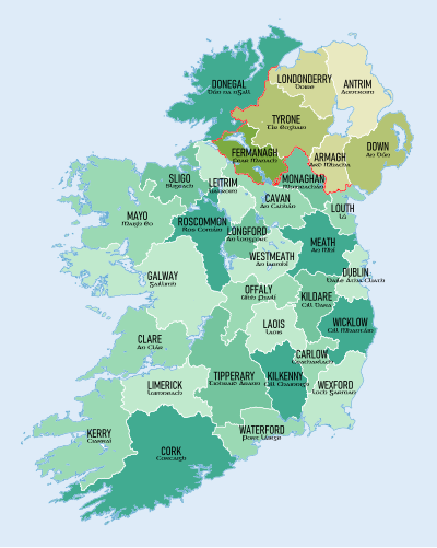
This is a list of counties of Ireland ordered by population. Counties in the Republic of Ireland are shown in normal type, while those in Northern Ireland are listed in italic type. Non-traditional administrative counties are indicated by a cream-coloured background.

For a more detailed analysis of current and historical Irish populations in the Republic of Ireland, see Irish population analysis. The population of the six counties of Northern Ireland as of 2021 is 1,903,100[1] which would mean a total population on the island of Ireland as of 2022 of approximately 7,052,314.
Data source (as of June 2023):
- Taken from latest census data for the Republic of Ireland[2] and Northern Ireland.[3]
- Population data for counties in the Republic of Ireland is based on data from the 2022 census.
- Population data for counties in Northern Ireland is based on the 2021 census.
- The previous census for the Republic of Ireland was taken in 2016, the previous census for Northern Ireland was taken in 2011.
- Density updated as of 2021 for Northern Ireland and 2022 for the Republic of Ireland.
| Rank | County | Population | Density (km2) | Province | Change since previous census | Change per year |
|---|---|---|---|---|---|---|
| 1 | Dublin | 1,458,154 | 1,581.5 | Leinster | ||
| 2 | Antrim | 651,321 | 211.1 | Ulster | ||
| 3 | Cork | 584,156 | 77.5 | Munster | ||
| 4 | Down | 553,261 | 222.3 | Ulster | ||
| – | Fingal | 330,506 | 724.8 | Leinster | ||
| – | South Dublin | 301,705 | 1,354.5 | Leinster | ||
| 5 | Galway | 277,737 | 45.1 | Connacht | ||
| 6 | Londonderry | 252,231 | 119.1 | Ulster | ||
| 7 | Kildare | 247,774 | 146.2 | Leinster | ||
| – | Dún Laoghaire–Rathdown | 233,860 | 1,859.0 | Leinster | ||
| 8 | Meath | 220,826 | 94.3 | Leinster | ||
| 9 | Limerick | 209,536 | 76.0 | Munster | ||
| 10 | Armagh | 194,394 | 146.5 | Ulster | ||
| 11 | Tyrone | 188,383 | 57.6 | Ulster | ||
| 12 | Tipperary | 167,895 | 39.0 | Munster | ||
| 13 | Donegal | 167,084 | 34.4 | Ulster | ||
| 14 | Wexford | 163,919 | 69.3 | Leinster | ||
| 15 | Kerry | 156,458 | 32.5 | Munster | ||
| 16 | Wicklow | 155,851 | 76.9 | Leinster | ||
| 17 | Louth | 139,703 | 169.1 | Leinster | ||
| 18 | Mayo | 137,970 | 24.7 | Connacht | ||
| 19 | Clare | 127,938 | 37.1 | Munster | ||
| 20 | Waterford | 127,363 | 68.6 | Munster | ||
| 21 | Kilkenny | 104,160 | 50.2 | Leinster | ||
| 22 | Westmeath | 96,221 | 52.3 | Leinster | ||
| 23 | Laois | 91,877 | 53.4 | Leinster | ||
| 24 | Offaly | 83,150 | 41.6 | Leinster | ||
| 25 | Cavan | 81,704 | 42.3 | Ulster | ||
| 26 | Roscommon | 70,259 | 27.6 | Connacht | ||
| 27 | Sligo | 70,198 | 38.2 | Connacht | ||
| 28 | Monaghan | 65,288 | 50.4 | Ulster | ||
| 29 | Fermanagh | 63,585 | 37.6 | Ulster | ||
| 30 | Carlow | 61,968 | 69.1 | Leinster | ||
| 31 | Longford | 46,751 | 42.9 | Leinster | ||
| 32 | Leitrim | 35,199 | 21.9 | Connacht | ||
| Total | Island of Ireland | 7,052,314 | 83.5 | — | ||
| Average | 220,385 | — | — |
See also
Notes
- The populations of Dublin, Cork, Galway, Limerick and Waterford cities are included with the respective traditional counties. For a list of these cities and their suburbs by population see, List of urban areas in the Republic of Ireland. For more information on city status, see City status in Ireland.
References
- ^ "Archived copy" (PDF). Archived from the original (PDF) on 24 December 2012. Retrieved 16 December 2014.
{{cite web}}: CS1 maint: archived copy as title (link) NISRA Key Report, 2011 - ^ "Census 2022 - Summary Results - FY003A- Population". 30 May 2023. Retrieved 3 June 2023.
- ^ "County". NISRA. Retrieved 17 August 2023.
🔥 Top keywords: Akademia e Shkencave e RPS te ShqiperiseAlexandria Ocasio-CortezBilderberg GroupCristiano RonaldoDong XiaowanMinecraftOperation GladioPrimal cutRiot FestStrictly Come Dancing (series 7)Main PageSpecial:SearchWikipedia:Featured picturesUEFA Euro 2024Derek JeterJamal MusialaBridgertonInside Out 2UEFA European Championship2024 ICC Men's T20 World CupCleopatraThe Boys (TV series)The Boys season 4Deaths in 2024Pawan KalyanNATO phonetic alphabetUEFA Euro 2020ChatGPTG7Giorgia Meloni.xxxYouTubeNicola CoughlanGermany national football teamBiggest ball of twineOpinion polling for the 2024 United Kingdom general electionJuneteenthJerry WestFlag Day (United States)Project 2025Scotland national football teamJulian NagelsmannDutch rollAndrew McCarthyDonald TrumpThe Acolyte (TV series)ICC Men's T20 World CupFlorian WirtzHit Man (2023 film)