Fitxer:Atlantic cable Map.jpg
Fitxer original (1.493 × 600 píxels, mida del fitxer: 163 Ko, tipus MIME: image/jpeg)
| Aquest fitxer i la informació mostrada a continuació provenen del dipòsit multimèdia lliure Wikimedia Commons. |
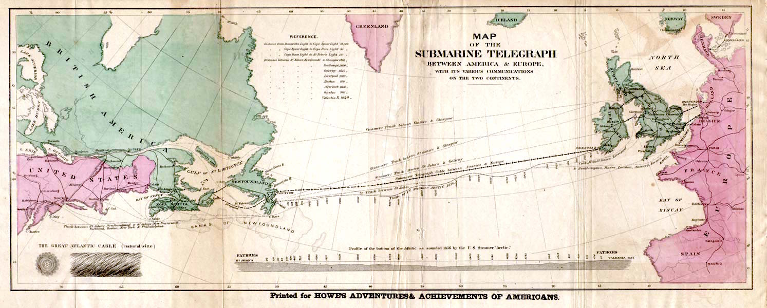
| Descripció | English: Map of the 1858 Atlantic Cable route (from http://atlantic-cable.com/Maps/index.htm). Français : Carte des routes de câbles sous-marins transatlatiques de 1858. Русский: Карта прокладки телеграфного кабеля через Атлантику в 1858 г. Українська: Карта першого трансатлантичного телеграфного кабеля в 1858 р. |
| Data | the 1858 |
| Font | Howe's Adventures & Achievements of Americans; en:Image:Atlantic_cable_Map.jpg |
| Autor | Desconegut |
| Permís (Com reutilitzar aquest fitxer) | English: Image is out of copyright, but the scan used here was sourced from http://atlantic-cable.com/Maps/index.htm without my permission (I am the site owner). I grant permission for use of the scan on Wikipedia. Українська: Зображення не захищене авторським правом, але сканування, яке тут використовується, було отримано з http://atlantic-cable.com/Maps/index.htm без мого дозволу (я власник сайту). Надаю дозвіл на використання сканування у Вікіпедії. |
Aquest material està en domini públic als Estats Units i als altres països on el dret d'autor s'estén per 70 anys (o menys) després de la mort de l'autor.
| |
| Aquest fitxer està identificat com a lliure de restriccions conegudes sota la llei de drets d'autor, inclosos els drets veïns. | |
Aquest fitxer és en el domini públic en els Estats Units. Això és aplicable a obres dels EUA on el copyright ha expirat, sovint perquè la seva primera publicació va ser abans de l'1 de gener de 1929. Vegeu aquesta pàgina per a més detalls. |  | |
 | Podria ser que aquesta imatge no estigui en el domini públic fora dels Estats Units (especialment on no s'aplica la regla del termini més curt per obres dels EUA, com Canada, la Xina continental (no a Hong Kong ni Macau), Alemanya, Mèxic i Suïssa). El creador i any de publicació són informació essencial i s'han de proporcionar. Vegeu Viquipèdia:Drets d'autor per a més detalls. |
Historial del fitxer
Cliqueu una data/hora per veure el fitxer tal com era aleshores.
| Data/hora | Miniatura | Dimensions | Usuari/a | Comentari | |
|---|---|---|---|---|---|
| actual | 16:35, 29 gen 2018 | 1.493 × 600 (163 Ko) | Soerfm | Color, brightness | |
| 17:53, 9 març 2006 | 1.493 × 600 (136 Ko) | Jailbird | Map of the 1858 Atlantic Cable route from Frank Leslie's Illustrated Newspaper, August 21, 1858 from en:Image:Atlantic_cable_Map.jpg {{PD-Old}} |
Ús del fitxer
Les 2 pàgines següents utilitzen aquest fitxer:
Ús global del fitxer
Utilització d'aquest fitxer en altres wikis:
- Utilització a az.wikipedia.org
- Utilització a be-tarask.wikipedia.org
- Utilització a bs.wikipedia.org
- Utilització a cs.wikipedia.org
- Utilització a de.wikipedia.org
- Utilització a en.wikipedia.org
- Utilització a en.wikibooks.org
- Utilització a en.wikivoyage.org
- Utilització a eo.wikipedia.org
- Utilització a es.wikipedia.org
- Utilització a et.wikipedia.org
- Utilització a eu.wikipedia.org
- Utilització a fa.wikipedia.org
- Utilització a fi.wikipedia.org
- Utilització a fr.wikipedia.org
- 1866
- Câble sous-marin
- Extel
- Câbles télégraphiques transatlantiques
- Discussion:Câbles télégraphiques transatlantiques
- Wikipédia:Statistiques des anecdotes de la page d'accueil/Visibilité des anecdotes (2021)
- Discussion:Câbles télégraphiques transatlantiques/LSV 19995
- Wikipédia:Statistiques des anecdotes de la page d'accueil/Visibilité des anecdotes (2021)/2021 04
- Projet:Aide et accueil/Twitter/Tweets/archives/avril 2021
- Wikipédia:Le saviez-vous ?/Archives/2021
- Wikipédia:Le Bistro/5 août 2022
- Télégraphie électrique
- Utilització a gd.wikipedia.org
- Utilització a id.wikipedia.org
- Utilització a io.wikipedia.org
- Utilització a it.wikipedia.org
- Utilització a ja.wikipedia.org
- Utilització a kk.wikipedia.org
Vegeu més usos globals d'aquest fitxer.