Datoteka:Ferry light trail, Rostock.jpg

Veličina ovog prikaza: 800 × 450 piksela. Ostale rezolucije: 320 × 180 piksela | 640 × 360 piksela | 1.024 × 576 piksela | 1.280 × 720 piksela | 2.560 × 1.440 piksela | 4.000 × 2.250 piksela.
Izvorna datoteka (4.000 × 2.250 piksela, veličina datoteke: 7,76 MB, MIME tip: image/jpeg)
| Ova datoteka je s Wikimedia Commonsa. Opis s njene stranice opisa datoteke prikazan je ispod. Commons je skladište slobodnih medija i datoteka za sve projekte fondacije Wikimedia. Možete i Vi pomoći. |
Sažetak
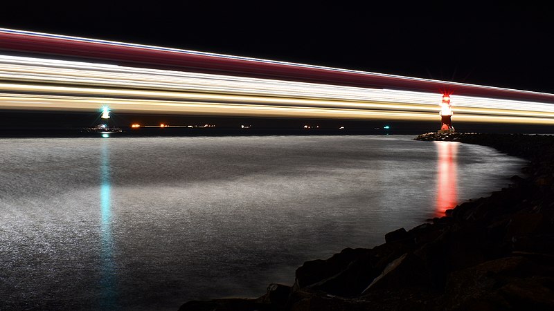
| Opis | English: Light trail of the largest German ferry M/S Mecklenburg-Vorpommern on its way from Rostock to Trelleborg: Aperture f/20, Exposure time 219 seconds العربية: مسار أضواء أكبر عبارة ألمانية في وانيموند في ألمانيا বাংলা: বৃহত্তম জার্মান ফেরি এম/এস মেকলেনবার্গ-ভোর্পোমারনের বাতির চিহ্নরেখা। বার্নামুন্ডে, জার্মানি। Bosanski: Svjetlosni trag najvećeg njemačkog trajekta M/S Mecklenburg-Vorpommern u Warnemündeu, Njemačka Čeština: Světelná stopa největšího německého trajektu M/S Mecklenburg-Vorpommern v přístavu města Warnemünde u Baltského moře Deutsch: Lichtspur der größten deutschen Fähre M/S Mecklenburg-Vorpommern auf dem Weg von Rostock nach Trelleborg: Blende f/20, Belichtungszeit 219 Sekunden Español: Sendero de luz del transbordador alemán M/S Mecklenburg-Vorpommern en Warnemünde, Alemania: Apertura f/20, Velocidad de obturación 219 segundos Esperanto: Luma spuro de la plej granda germana pramo "M/S Meklenburgo-Antaŭpomerio" en Warnemünde, Germanio Français : Les traces lumineuses du Mecklenburg-Vorpommern, l'un des plus larges ferries allemands, à Warnemünde Magyar: A legnagyobb német kompnak, az MS Mecklenburg-Vorpommernnek a fénycsíkja (Warnemünde, Németország) Nederlands: Lichtspoor van de spoorpont Mecklenburg-Vorpommern, de grootste Duitse veerboot, onderweg van Rostock naar Trelleborg Polski: Ślad światła największego niemieckiego promu M/S Mecklenburg-Vorpommern wypływającego z Rostocku do Trelleborga: Apertura f/20, Czas naświetlania 219 sekund Português: Rastro de luz da maior balsa alemã, M/S Mecklenburg-Vorpommern, em Warnemünde, Alemanha Українська: Світловий слід від найбільшого німецького порому M/S Мекленбург-Передня Померанія на шляху від Ростока до Треллеборга: Діафрагма f/20, час витримки 219 секунд |
| Datum | Taken on 2 januar 2021, 22:12:18 |
| Izvor | Vlastito djelo |
| Autor | Radomianin |
| Ostale verzije |
|

| Camera location | | View this and other nearby images on: OpenStreetMap |
|---|
| Pripisivanje (required by the license) | © Radomianin / Wikimedia Commons / CC BY-SA 4.0 |
| Using this image | You can use this image file free of charge under the terms of the free license CC BY-SA 4.0. In particular, this means:
|
| Editing this image |
|
The photo was taken from the east mole in the district Hohe Düne, view from southeast.
Assessment
|
This image was selected as picture of the day on Wikimedia Commons for 20 May 2021. It was captioned as follows: Other languages: Bosanski: Svjetlosni trag najvećeg njemačkog trajekta M/S Mecklenburg-Vorpommern u Warnemündeu, Njemačka Čeština: Světelná stopa největšího německého trajektu M/S Mecklenburg-Vorpommern v přístavu města Warnemünde u Baltského moře Esperanto: Luma spuro de la plej granda germana pramo "M/S Meklenburgo-Antaŭpomerio" en Warnemünde, Germanio Français : Les traces lumineuses du Mecklenburg-Vorpommern, l'un des plus larges ferries allemands, à Warnemünde Magyar: A legnagyobb német kompnak, az MS Mecklenburg-Vorpommernnek a fénycsíkja (Warnemünde, Németország) Nederlands: Lichtspoor van de spoorpont Mecklenburg-Vorpommern, de grootste Duitse veerboot, onderweg van Rostock naar Trelleborg Polski: Ślad światła największego niemieckiego promu M/S Mecklenburg-Vorpommern w Warnemünde, Niemcy Português: Rastro de luz da maior balsa alemã, M/S Mecklenburg-Vorpommern, em Warnemünde, Alemanha Українська: Світловий слід від найбільшого німецького порому M/S Мекленбург-Передня Померанія у Варнемюнде, Німеччина বাংলা : বৃহত্তম জার্মান ফেরি এম/এস মেকলেনবার্গ-ভোর্পোমারনের বাতির চিহ্নরেখা। বার্নামুন্ডে, জার্মানি। العربية : مسار أضواء أكبر عبارة ألمانية في وانيموند في ألمانيا. |
Licenciranje
Ja, vlasnik autorskog prava ovog djela, ovdje ga objavljujem pod sljedećom licencom:
This file is licensed under the Creative Commons Attribution-Share Alike 4.0 International license.
- Slobodni ste:
- da dijelite – da kopirate, distributirate i prenosite djelo
- da remiksate – da prilagodite djelo
- Pod sljedećim uslovima:
- pripisivanje – Morate pripisati odgovarajuće autorske zasluge, osigurati link ka licenci i naznačiti jesu li napravljene izmjene. To možete uraditi na bilo koji razumni način, ali ne tako da se sugerira da davalac licence odobrava Vas ili Vašu upotrebu njegovog djela.
- dijeli pod istim uslovima – Ako mijenjate, transformišete ili nadograđujete ovaj materijal, morate ga objaviti i distribuirati samo pod istom ili sličnom licencom poput ove.
Historija datoteke
Kliknite na datum/vrijeme da vidite verziju datoteke iz tog vremena.
| Datum/vrijeme | Smanjeni pregled | Dimenzije | Korisnik | Komentar | |
|---|---|---|---|---|---|
| trenutno | 14:14, 20 februar 2021 | | 4.000 × 2.250 (7,76 MB) | Radomianin | image cropping changed |
| 16:35, 17 februar 2021 |  | 4.047 × 2.277 (7,21 MB) | Radomianin | Uploaded own work with UploadWizard |
Upotreba datoteke
Nema stranica koje koriste ovu datoteku.
Globalna upotreba datoteke
Sljedeći wikiji koriste ovu datoteku:
- Upotreba na alt.wikipedia.org
- Upotreba na av.wikipedia.org
- Upotreba na be-tarask.wikipedia.org
- Upotreba na bn.wikipedia.org
- Upotreba na crh.wikipedia.org
- Upotreba na cv.wikipedia.org
- Upotreba na fr.wikipedia.org
- Upotreba na hu.wikipedia.org
- Upotreba na hy.wikipedia.org
- Upotreba na ka.wikipedia.org
- Upotreba na ko.wikipedia.org
- Upotreba na lbe.wikipedia.org
- Upotreba na lez.wikipedia.org
- Upotreba na mk.wikipedia.org
- Upotreba na os.wikipedia.org
- Upotreba na pl.wikipedia.org
- Upotreba na pt.wikipedia.org
- Upotreba na ru.wikipedia.org
- Upotreba na ru.wikinews.org
- Upotreba na sah.wikipedia.org
- Upotreba na uk.wikipedia.org
- Upotreba na vep.wikipedia.org
- Upotreba na zh.wikipedia.org
Metapodaci
🔥 Top keywords: