Riverside Drive is a scenic north–south boulevard in the New York City borough of Manhattan. The road runs on the west side of Upper Manhattan, generally paralleling the Hudson River and Riverside Park between 72nd Street and the vicinity of the George Washington Bridge at 181st Street. North of 96th Street, Riverside Drive is a wide divided roadway. At several locations, a serpentine service road diverges from the main road, providing access to the residential buildings. The avenue was opened in 1880, and several viaducts were completed over the subsequent decades to connect the various segments of Riverside Drive.
 1 Riverside Drive at 72nd Street, (C.P.H. Gilbert, architect. Now a satellite location for the Islamic Cultural Center of New York) | |
| Namesake | Hudson River |
|---|---|
| Owner | City of New York |
| Maintained by | NYCDOT |
| Location | Manhattan, New York City |
| South end | 72nd Street in Upper West Side |
| North end | 181st Street in Washington Heights Dyckman Street in Inwood (disconnected segment) |
| East | West End Avenue (72nd–107th Sts) Broadway (107th–116th, 127–159th Sts) Claremont Avenue (116th–127th Sts (Tiemann Pl)) Fort Washington Avenue (159th–168th Sts) Haven Avenue (168th–181st Sts) |
| West | Henry Hudson Parkway |
| Construction | |
| Commissioned | March 1811 |
| Completion | 1910[1] |
History
editDevelopment
editThe 191 acres (0.77 km2) of land in the original park between 72nd to 125th Streets were originally inhabited by the Lenape people, but by the 18th century were used for farms by the descendants of European colonists.[2]: 68 In 1846, the Hudson River Railroad (later the West Side Line and Hudson Line) was built along the waterfront, connecting New York City to Albany.[3]: 3 [4] In 1865, Central Park commissioner William R. Martin put forth the first proposal for a riverside park along the Hudson River.[3]: 3 [4][5] An act providing for such was presented to the Legislature by commissioner Andrew Haswell Green in 1866 and approved the same year.[6]: 9 The first segment of Riverside Park was acquired through condemnation in 1872.[1] The park also included the construction of Riverside Drive (then known as Riverside Avenue), a tree-lined drive curving around the valleys and rock outcroppings, overlooking the future park and the waterfront. The avenue was laid out in 1868 and was 100 feet (30 m) wide for its entire length.[6]: 9 [7] The plans for Riverside Park and Avenue brought the attention of William M. Tweed, who bought several lots adjacent to the park in anticipation of its construction.[6]: 9
A selection process for the designers of Riverside Park followed, and in 1873 the commissioners selected Frederick Law Olmsted, a park commissioner who had also designed Central Park.[3]: 4 [4] Initially, Riverside Avenue had been planned to run in a straight line, which would have required a retaining wall and extensive fill.[2]: 69 By then, the difficult topography of the area had come to the attention of the Manhattan park commissioners, and in 1873 Olmsted was given the authorization to redesign the grade of Riverside Avenue. To accommodate this, Olmsted devised a new plan that would create a main road extending from 72nd to 123rd Streets, with overpasses at 79th and 96th Streets, as well as "carriage roads" to serve the nearby neighborhood. The grade of the road was not to exceed 1:27.[2]: 71 [6]: 10 [7] Riverside Avenue's main road would contain two roadways, one for each direction, separated by a median. A pedestrian path and a horse path would run alongside the avenue, and trees would provide shade along the route.[2]: 71
Over the following years, work proceeded on Riverside Avenue, with various ramps and stairs to the park as well as a bridle path between 104th and 120th Streets. In 1876 Olmsted was asked to create plans for the design of the avenue as a country drive, but ultimately it was paved. In late 1876, bids were accepted for the paving of Riverside Avenue.[6]: 10 Olmsted was ousted as parks superintendent in December 1877.[8] From 1875 to 1910, architects and horticulturalists such as Calvert Vaux and Samuel Parsons laid out the stretch of park/road between 72nd and 125th Streets according to the English gardening ideal, creating the appearance that the park was an extension of the Hudson River Valley.[1]
The avenue was opened in 1880 and was well used by pedestrians, bikers, and drivers;[6]: 11 it had cost nearly $10 million.[9] By the end of the 19th century, nearly every lot on the eastern side of Riverside Drive had been developed with private mansions and apartment buildings. By comparison, there had been fewer than 10 houses between 72nd and 125th Streets on the shoreline before construction of the avenue began.[9]
Late 19th and early 20th centuries
editRiverside Drive's original northern terminus was at Grant's Tomb near 122nd Street.[9][10] In January 1897, state lawmakers proposed extending Riverside Drive northward to the Boulevard Lafayette near 157th Street, with a viaduct above Manhattan Valley from 122nd to 134th Street.[11][12] The original plans, which were to cost $10 million and included four viaducts, were quickly downsized to $2 million and one viaduct.[13] Shortly afterward, a similar bill with a reduced budget was proposed in the state legislature.[14] The revised bill called for the avenue to be narrowed in the vicinity of Trinity Cemetery at 153rd Street.[14][15] The governor of New York signed both bills in May 1897,[16][17] but work on the viaduct was delayed for several months.[18] That November, the city's Board of Street Opening and Improvement agreed to lengthen the viaduct slightly so that it ran from 122nd to 135th Street. The extension was budgeted at $3.6 million, with the viaduct alone costing $840,000.[19][20] At 153rd Street, Riverside Drive would be cantilevered over the West Side Line railroad tracks to avoid Trinity Church Cemetery.[10] The extension plans also involved demolishing several old mansions.[21]
96th Street overpass and Manhattan Valley Viaduct
editThe New York City Board of Estimate formally approved the Manhattan Valley Viaduct in December 1898,[22][23] and plans for the viaduct were drawn up within three weeks.[24] At the end of the month, the firm of O'Brien, Sheehan, and McBean was hired to build the viaduct for $570,000;[25][26] under the terms of the contract, the viaduct had to be completed in 400 days.[27] Work on the viaduct began in March 1898.[28] The viaduct's engineers requested in June 1898 that the approaches be made of granite rather than sandstone, which would add $80,000 to the cost;[29] the city's comptroller opposed the change.[30] The next month, the city authorized $86,500 in bonds to finance an overpass above 96th Street[31] and $500,000 in bonds for the Manhattan Valley Viaduct.[32][33]
The city's park commissioners began soliciting bids for the 96th Street overpass in June 1900[34] and awarded a contract the next month to A. C. Gildersleeve for $200,000.[35] Work on the 96th Street overpass began later the same year.[36] Meanwhile, the abutments for the Manhattan Valley Viaduct were finished by mid-1900.[37][38] The chief engineer of the city's highways departments reported in April 1901 that the Manhattan Valley Viaduct was completed except for filling and electrical work.[39] Work on the 96th Street overpass was delayed for two months due to difficulties in installing sewage pipes;[40] the overpass opened in January 1902[41][42] following complaints that the contractor was taking too long.[43] The Manhattan Valley Viaduct was completed in mid-1902.[9] The construction of the 96th Street overpass and Manhattan Valley Viaduct caused real-estate prices along Riverside Drive to increase in the 1900s.[44] Arc lamps were installed on the Manhattan Valley Viaduct in 1903, soon after it opened.[45]
Extension to 155th Street
editThe city's corporation council began condemning land for the extension of Riverside Drive north of the Manhattan Valley Viaduct in mid-1899,[46] and three commissioners were appointed to condemn the land the next year.[47] The city acquired the land in September 1900.[48] Most of the condemned sites had been small plots, except for a tract between 142nd and 144th Streets that had belonged to the Hoguet family.[9] The project was split into two phases, section 1 between 135th and 153rd Streets, and section 2 between 153rd Street and the Boulevard Lafayette. By August 1901, plans for section 1 had been completed, with that section estimated to cost $1.7 million.[49][50] The extension would consist of a 60-foot-wide (18 m) roadway, a 20-foot-wide (6.1 m) carriage path, two sidewalks, and grass planting strips. There were also to be four bridges carrying the avenue between 135th and 156th Streets.[51][52] Along with the Boulevard Lafayette (which extended north of Broadway and 156th Street[53]), the Riverside Drive extension would form part of a 20-mile (32 km) parkway that would connect with Harlem River Drive.[39][54] Construction did not start for over two years after the city acquired land for the Riverside Drive extension.[48] In the meantime, dirt from the excavation of the city's first subway line was dumped on the path of the extension.[55]
A state judge ruled in April 1903 that construction of the Riverside Drive extension had to start as soon as possible,[56] and a groundbreaking ceremony for the extension occurred on December 12, 1903.[57][58] The section from 135th to 145th Street was awarded to Ryan & Parker, while the section from 145th to 155th Street was awarded to John C. Rodgers; work on both sections began in May 1904.[9] The section of Riverside Drive north of 150th Street was much higher than the streets that it intersected, prompting residents of these cross-streets to complain that their vehicles could not access Riverside Drive.[59] The plans also included widening the Boulevard Lafayette within the Washington Heights neighborhood and constructing a service road to the east of the existing boulevard. Because people frequently referred to the Boulevard Lafayette by several incorrect names, residents of Washington Heights also wanted the Boulevard Lafayette to be renamed Riverside Drive.[9]
The city planned to acquire land to widen the section of the Boulevard Lafayette (then renamed Riverside Drive) between 158th and 165th Streets in 1907, but the city's controller objected to the $1 million valuation placed on the land.[60][61] By mid-1908, Riverside Drive was complete to 155th Street, except for a single city block between 151st and 152nd Streets, where a property owner had successfully requested that a state judge place an injunction on the project.[62] A few blocks north, families with plots in Trinity Church Cemetery complained that the new road was obstructing views of the Hudson River from their plots.[63]
Late 1900s to 1920s
editAs early as 1906, engineers considered extending Riverside Drive further north from 158th Street to the proposed Henry Hudson Bridge.[64] In 1908, the Board of Estimate declined to provide an appropriation for the further extension of Riverside Drive, saying the city did not have enough money.[65] That year, the entire avenue was renamed Riverside Drive.[6]: 10 Olmsted and Arnold W. Brunner recommended in 1913 that Riverside Drive be extended north to the Bronx, with a new viaduct connecting 155th Street and the Boulevard Lafayette.[66]
Around 122nd Street, the avenue split into two roadways, one each to the west and east of Grant's Tomb; both roadways originally carried two-way traffic. After a pedestrian was killed in 1915, the roadway to the west of the tomb was converted to carry one-way southbound traffic, while the roadway to the east was converted to carry one-way northbound traffic.[67]
In late 1926, the Municipal Art Commission approved the construction of a viaduct carrying Riverside Drive West between 155th and 161st Street in Hamilton Heights.[68][69] At the time, traffic was forced to divert onto narrow local roads to continue along Riverside Drive in either direction.[70] Workers began constructing foundations for the viaduct the same year.[71] The P. T. Cox Construction Co. was hired in April 1927 to provide 5,000 short tons (4,500 long tons; 4,500 t) of structural steel for the viaduct.[72] Later that year, a state judge determined that it would cost $3.3 million to acquire land for a northward extension of Riverside Drive.[73] The viaduct was opened on November 28, 1928; it had cost $2.36 million.[74][75] There were also plans to repave the Manhattan Valley Viaduct, which had been built with a wooden-block roadbed that was starting to deteriorate.[76]
Riverside Park expansion and late 20th century
edit
In the 1930s, New York Central Railroad's rail track north of 72nd Street was covered in a Robert Moses project called the West Side Improvement.[77] Moses' biographer Robert Caro described Moses surveying the area prior to his project, and seeing:
a wasteland six miles (10 km) long, stretching from where he stood all the way north to 181st street.... The 'park' was nothing but a vast low-lying mass of dirt and mud.... Unpainted, rusting, jagged wire fences along the tracks barred the city from its waterfront...The engines that pulled trains along the tracks burned coal or oil; from their smokestacks, a dense black smog rose toward the apartment houses, coating windowsills with grit.... [a stench] seemed to hang over Riverside Drive endlessly after each passage of a train carrying south to the slaughterhouses in downtown Manhattan carload after carload of cattle and pigs.... [Once, Frances Perkins ] heard Moses exclaim, "Isn't this a temptation to you? Couldn't this waterfront be the most beautiful thing in the world?"[78]
The Moses project, which was bigger than the Hoover Dam project, created the Henry Hudson Parkway, buried the West Side Line in the Freedom Tunnel, and greatly expanded Riverside Park.[79] In addition, in the mid-1930s, city officials extended Riverside Drive northward to the Henry Hudson Bridge; this extension became part of Henry Hudson Parkway.[80]
The Manhattan Valley Viaduct in Manhattanville underwent a two-year-long reconstruction in 1961. Another renovation project for the viaduct was scheduled in 1981, at which point the project was to cost $27 million. Work started in 1985, after the deck had corroded significantly, prompting officials to spend another $9.5 million replacing girders.[81]
Riverside South
edit
In the 1980s Donald Trump, then owner of the 57 acres (230,000 m2) of land just south of Riverside Park that had been the Penn Central freight rail yard, proposed a very large real estate development project.[82] However, hampered by his weakened financial condition and opposed by six civic groups (Municipal Art Society, Natural Resources Defense Council, New Yorkers for Parks, Regional Plan Association, Riverside Park Fund, and Westpride), Trump agreed in 1990 to their plan, which was designed to mimic Riverside Park and Drive further north. Though scaled down, the project is still the second biggest private real estate venture under construction in New York City.[83][84]
The agreed-upon plan would expand Riverside Park by 23 acres (93,000 m2) and extend Riverside Drive to the south as Riverside Boulevard. The new Riverside Park South, stretching between 72nd and 59th streets, is the central element of the development. Portions of the former rail yard, such as the New York Central Railroad 69th Street Transfer Bridge, are incorporated into the new park.[85]
Route
editStarting at 72nd Street, Riverside Drive passes through the Manhattan neighborhoods of the Upper West Side, Morningside Heights, over Manhattanville in West Harlem by way of the Riverside Drive Viaduct and through Washington Heights. Below 72nd Street, Riverside Drive continues as Riverside Boulevard which stretches through Riverside South to 59th Street where it merges into the West Side Highway.
Only a few stretches of Riverside Drive were built along an older road; due to the hilly terrain, Riverside Drive crosses a natural cleft in the bedrock at 87th Street on an iron viaduct and passes over 96th Street, Tiemann Place and 135th Street, and 158th Street on further viaducts. At Tiemann Place and 135th Street, and at 158th Street, an old alignment is present, also named Riverside Drive, while the viaduct portion or main route is officially named and signed "Riverside Drive West". The viaduct between Tiemann Place and 135th Street is called the Manhattan Valley Viaduct.
At its north end, Riverside Drive merges with the northbound lanes of the Henry Hudson Parkway; when the parkway was built, the Henry Hudson's northbound lanes used the roadway of Riverside Drive. In 2005, the retaining wall of Castle Village collapsed onto both Riverside Drive and the northbound lanes of the Henry Hudson Parkway.[86] The wall was repaired and the roadway reopened in March 2008.[87]
North of 158th Street the right of way which currently carries the name Riverside Drive was known as Boulevard Lafayette, which led to Plaza Lafayette in Hudson Heights. The section exiting the parkway at the Dyckman Street exit and ending at Broadway is still known as Riverside Drive.
The M5 New York City Bus route serves Riverside Drive from 72nd to 135th Streets, while the Bx6 and Bx6 SBS terminate at Riverside Drive and 158th Street.[88]
Viaducts
edit96th Street
editA small bridge carries Riverside Drive over 96th Street. When this overpass was built, it was described as a viaduct with buttresses and stone terraces leading down to Riverside Park and the Hudson River. Semicircular shelters were also built next to the viaduct on either side of 96th Street.[89] Although the overpass is clad with stone, its superstructure is made of steel.[36]
Manhattan Valley Viaduct
editBetween Tiemann Place and 135th Street is a viaduct that carries Riverside Drive above 12th Avenue; built in 1901, it is variously called the 125th Street Viaduct, Riverside Drive Viaduct,[81] or Manhattan Valley Viaduct.[22] Francis Stuart Williamson was the chief engineer for the viaduct.[90] Despite the structure's utilitarian role as a highway, it was also a strong symbol of civic pride, inspired by America's late 19th-century City Beautiful movement. The viaduct's original roadway, wide pedestrian walks and overall design was highly ornamented.[90] The New-York Tribune described the viaduct in 1900 as "another attractive feature [on] the already impressively beautiful east bank of the Hudson River at Riverside Park and Washington Heights".[37]
As planned, the viaduct measured 1,564 feet (477 m) long, excluding the approaches. The viaduct carries a roadway measuring 60 feet (18 m) wide, as well as a 10-foot (3.0 m) wide sidewalk on either side of the viaduct.[28][90] The viaduct measures 95 feet (29 m) above mean high water at 125th Street and 75 feet (23 m) above mean high water at 135th Street.[28] It is divided into 26 bays, each comprising a single span. Twenty-two of the spans are 65 feet (20 m) long; one of the spans, crossing 125th Street, is 128 feet (39 m) long; and the three northernmost spans are of irregular length.[28] Each arch is composed of latticed plate girders measuring 3 feet (0.91 m) long.[90] Under the roadway are 60-foot-wide (18 m) transverse steel girders, which were built in several pieces and riveted together;[81] each girder is 5 feet (1.5 m) deep.[90] The main span above 125th Street is supported by two plate girders measuring 130 by 10 by 8 feet (39.6 by 3.0 by 2.4 m) across,[90] which were described as the world's largest steel girders at the time of the viaduct's completion.[90][91]
Including the approaches to the south and north, the viaduct has a total length of 2,044 feet (623 m)[22][28] or 2,074 feet (632 m).[90] The northern approach is 262 feet (80 m) long, while the southern approach is 218 feet (66 m) long.[28] The approaches are of rock-faced Mohawk Valley limestone with Maine granite trimmings, the face work being made up of courses of ashlar. The southern approach consists of a semicircular wall with stone staircases on either side.[90] This was intended to give a broad plaza effect, which was intended to impart deliberate grandeur to the natural terminus of much of Riverside Drive's traffic as well as to give full advantage to the vista overlooking the Hudson River and New Jersey Palisades to the west.[92][93] There is also a single masonry arch with a glazed-brick vault next to the southern approach.[37]
 125th Street Viaduct
 Under construction
 Below, facing north
 Below, facing south


155th to 161st Street
editAnother viaduct carries Riverside Drive between 155th and 161st Streets. This viaduct is .25 miles (0.40 km) long and 60 feet (18 m) wide, carrying six lanes of traffic. The structure is made of steel and stone, and the arches under the roadway are infilled with granite or paneled concrete and are topped by metal-framed windows. The roadway itself has granite balustrades with ornamental lampposts.[70]
Buildings and monuments
editResidential buildings
edit
At the end of the 19th century, the eastern side of Riverside Drive was a series of luxuriously finished rowhouses interspersed with free-standing nineteenth century mansions set in large lawns.[94][95] The Isaac L. Rice Mansion at 89th Street, and the Schinasi Mansion at 107th Street, are the only two remaining freestanding mansions on Riverside Drive.[96]
The Charles M. Schwab House, built in 1905 for steel magnate Charles M. Schwab on a full city block between 73rd and 74th Streets, was replaced in 1950 by the 18-story Schwab House apartment building.[97] The Normandy, an Art Moderne and Renaissance Revival apartment house between 86th and 87th Streets, is a New York City designated landmark.[98] The Master Apartments at 310 Riverside Drive, a 27-story Art Deco tower,[99] is the 370 Riverside Drive building, which was erected in 1922–23 for approximately $800,000 by Simon Schwartz and Arthur Gross.[100] International House is at 500 Riverside Drive, the next building north of Riverside Church, facing Grant's Tomb, with a back entrance on Claremont Avenue. Among the other apartment houses are the curved facades of The Colosseum and The Paterno and the Cliff-Dwellers Apartments at 96th Street, with mountain lions and buffalo skulls on its friezes.
Other structures
editThe Nicholas Roerich Museum is on 107th Street and Riverside Drive. The Interchurch Center and Riverside Church are located at 120th Street and Riverside Drive, while Sakura Park is located two blocks north. Other attractions on Riverside Drive include Riverbank State Park, Trinity Church Cemetery, Columbia-Presbyterian Medical Center, and Fort Washington Park.
Among the monuments along its route are the Eleanor Roosevelt Monument at 72nd Street,[101] the Soldiers' and Sailors' Monument at 89th Street,[102] Anna Hyatt Huntington's Joan of Arc at 93rd Street,[103] a monument to John Merven Carrère by Thomas Hastings at 99th Street,[104] Attilio Piccirilli's Fireman's Memorial at 100th Street,[105] and the Amiable Child Monument and Grant's Tomb at 122nd Street.[94]
Notable residents
edit- Marian Anderson (1897–1993), contralto and one of the most celebrated singers of the twentieth century; lived at 730 Riverside Drive.[106][107]
- Hannah Arendt (1906–1975), political theorist, lived at 370 Riverside Drive from 1959 until her death in 1975.
- Saul Bellow (1915–2005), author, lived at 333 Riverside Drive in the 1950s[108]
- Rafael Díez de la Cortina y Olaeta (1859–1939), linguist, resident of 431 Riverside Drive[109]
- Ralph Ellison (1913–1994), writer, longtime resident of 730 Riverside Drive.[107]
- Alfred T. Fellheimer (1875–1959), lead architect for Grand Central Terminal and Cincinnati Union Terminal; lived at 730 Riverside Drive.[106]
- George Gershwin (1898–1937), composer and pianist; occupied a penthouse at 33 Riverside Drive.[110]
- Ira Gershwin (1896–1983), lyricist; occupied a penthouse at 33 Riverside Drive, adjoining his brother's apartment.[110]
- Katie Halper, American comedian, writer, journalist, filmmaker, podcaster, political commentator, and teacher.[111]
- William Randolph Hearst (1863–1951), newspaper publisher; owned a five-story penthouse in the Clarendon at 137 Riverside Drive[112]
- John and Faith Hubley lived together and operated their Academy Award-winning independent animation studio from their apartment at 110 Riverside Drive.[113]
- Jacob K. Javits (1904–1986), United States Senator from New York from 1957 to 1981; lived at 730 Riverside Drive.[106][107]
- Uwe Johnson, German author[114]
- Paul Krugman, Nobel Prize in economics winner[115]
- J. Robert Oppenheimer, Frank Oppenheimer and their parents lived at 155 Riverside Drive on 88th Street.[116]
- Sergei Rachmaninoff owned a townhouse at 33 Riverside Drive, the predecessor to the present apartment block.[117]
- Bolesław Wieniawa-Długoszowski, Polish general, adjutant to Chief of State Józef Piłsudski, politician, diplomat and formally for one day the President of the Republic of Poland lived at 3 Riverside Drive.[118]
- Grantland Rice, American sportswriter[119]
- Jim Rogers, investor and financial commentator[120]
- Damon Runyon, American newspaper man and author[119]
- Babe Ruth, lived at 173 Riverside Drive, then 110 Riverside Drive[121]
- Thomas Sowell, American economist and social theorist, lived on the ground floor of a building on 152nd Street and Riverside Drive in the early 1950s[122]
In popular culture
edit- The part of the drive over the 125th Street Viaduct has been seen in the movie The Amazing Spider-Man (2012).[123]
- Scenes from Woody Allen's Manhattan (1979) were filmed at 265 Riverside Drive.[124]
- She'll Drive the Big Car on David Bowie's Reality (2003) album features a woman driving along Riverside Drive.[125]
Gallery
edit Near 165th Street
 At 158th Street
 At 145th Street
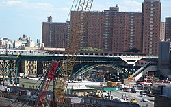 The 125th Street station on the IRT Seventh Avenue Line, seen from Riverside Drive's upper level
 Curved facades of The Colosseum and The Paterno at 116th Street
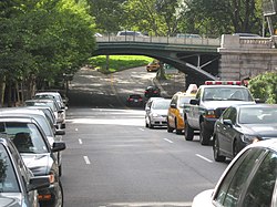 At 96th Street, which passes under Riverside Drive
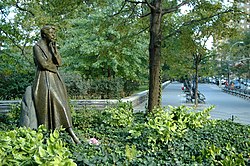 Riverside Drive's southern end at 72nd Street, looking north from the Eleanor Roosevelt Memorial Plaza


References
editNotes
Bibliography
- Stern, Robert A. M.; Gilmartin, Gregory; Mellins, Thomas (2009) New York 1930. New York: Rizzoli.
External links
edit- Carter Horsley, "Riverside Drive," The City Review.
 Media related to Riverside Drive (Manhattan) at Wikimedia Commons