The topographic isolation of a summit is the minimum distance to a point of equal elevation, representing a radius of dominance in which the peak is the highest point. It can be calculated for small hills and islands as well as for major mountain peaks and can even be calculated for submarine summits. Mount Everest, the highest point on Earth, has an undefined isolation, since there are no higher points to reference.[1]

A - Nearest higher neighbour
Because topographic isolation can be difficult to determine, a common approximation is the distance to a peak called the Nearest higher neighbour (NHN).[2]
Isolation table edit
The following sortable table lists Earth's 40 most topographically isolated summits.
| Rank | Summit | Landmass | Country | Elevation | Prominence | Isolation | Nearest higher neighbour |
|---|---|---|---|---|---|---|---|
| 1 | Mount Everest | Eurasia |  Nepal Nepal China China | 8848 m 29,029 ft | 8848 m 29,029 ft | n/a | n/a |
| 2 | Aconcagua | South America |  Argentina (Mendoza) Argentina (Mendoza) | 6962 m 22,841 ft | 6962 m 22,841 ft | 16,520 km 10,265 mi | Tirich Mir (Khyber Pakhtunkhwa, Pakistan) |
| 3 | Denali | North America |  United States (Alaska) United States (Alaska) | 6194 m 20,320 ft | 6149 m 20,174 ft | 7,450 km 4,629 mi | Yanamax (Xinjiang, China) |
| 4 | Kilimanjaro | Africa |  Tanzania Tanzania | 5895 m 19,341 ft | 5885 m 19,308 ft | 5,510 km 3,424 mi | Kuh-e Shashgal (Afghanistan) |
| 5 | Puncak Jaya | New Guinea |  Indonesia (Papua) Indonesia (Papua) | 4884 m 16,024 ft | 4884 m 16,024 ft | 5,262 km 3,269 mi | Jade Dragon Snow Mountain (Yunnan, China) |
| 6 | Vinson Massif | Antarctica | 4892 m 16,050 ft | 4892 m 16,050 ft | 4,861 km 3,020 mi | Risco Plateado (Mendoza, Argentina) | |
| 7 | Mont Orohena | Tahiti |  French Polynesia French Polynesia | 2241 m 7,352 ft | 2241 m 7,352 ft | 4,128 km 2,565 mi | Mount Ngauruhoe (New Zealand) |
| 8 | Mauna Kea | Hawai'i | United States (Hawai'i) | 4205 m 13,796 ft | 4205 m 13,796 ft | 3,947 km 2,453 mi | Mount Shasta (California, US) |
| 9 | Gunnbjørn Fjeld | Greenland |  Greenland Greenland | 3694 m 12,119 ft | 3694 m 12,119 ft | 3,254 km 2,022 mi | The Eiger (Canton of Bern, Switzerland) |
| 10 | Aoraki / Mount Cook | South Island |  New Zealand New Zealand | 3754 m 12,316 ft | 3754 m 12,316 ft | 3,140 km 1,951 mi | Mount Adam (Victoria Land, Antarctica) |
| 11 | Thabana Ntlenyana | Africa |  Lesotho Lesotho | 3482 m 11,424 ft | 2390 m 7,841 ft | 3,003 km 1,866 mi | Mount Meru (Tanzania) |
| 12 | Maunga Terevaka | Easter Island |  Chile Chile | 506 m 1,660 ft | 506 m 1,660 ft | 2,836 km 1,762 mi | Cerro de Los Inocentes (Alejandro Selkirk Island, Chile) |
| 13 | Mont Blanc | Eurasia |  France France Italy Italy | 4809 m 15,778 ft | 4696 m 15,407 ft | 2,813 km 1,748 mi | Kukurtlu Dome (Karachay-Cherkessia, Russia) |
| 14 | Piton des Neiges | Réunion | France | 3071 m 10,075 ft | 3071 m 10,075 ft | 2,767 km 1,720 mi | Giant's Castle (KwaZulu-Natal, South Africa) |
| 15 | Klyuchevskaya Sopka | Eurasia |  Russia (Kamchatka) Russia (Kamchatka) | 4750 m 15,584 ft | 4649 m 15,253 ft | 2,748 km 1,708 mi | Mount Foraker (Alaska, US) |
| 16 | Pico de Orizaba | North America |  Mexico (Puebla) Mexico (Puebla) | 5636 m 18,491 ft | 4922 m 16,148 ft | 2,690 km 1,672 mi | Pico Cristóbal Colón (Magdalena Department, Colombia) |
| 17 | Queen Mary's Peak | Tristan da Cunha |  Saint Helena, Ascension and Tristan da Cunha Saint Helena, Ascension and Tristan da Cunha | 2060 m 6,759 ft | 2060 m 6,759 ft | 2,665 km 1,656 mi | Mount Paget (South Georgia Island, UK) |
| 18 | Mount Whitney | North America | United States (California) | 4421 m 14,505 ft | 3072 m 10,080 ft | 2,649 km 1,646 mi | Nevado de Toluca (State of Mexico, Mexico) |
| 19 | Gunung Kinabalu | Borneo |  Malaysia (Sabah) Malaysia (Sabah) | 4095 m 13,435 ft | 4095 m 13,435 ft | 2,538 km 1,577 mi | Ngga Pilimsit (Papua, Indonesia) |
| 20 | Mount Elbrus | Eurasia | Russia (Kabardino-Balkaria) | 5642 m 18,510 ft | 4741 m 15,554 ft | 2,473 km 1,536 mi | Pik Agasis (Tajikistan) |
| 21 | Pico da Bandeira | South America |  Brazil (Espirito Santo) Brazil (Espirito Santo) | 2897 m 9,505 ft | 2647 m 8,684 ft | 2,393 km 1,487 mi | Cerro Naranjos (Bolivia) |
| 22 | Mont Cameroun | Africa |  Cameroon Cameroon | 4040 m 13,255 ft | 3901 m 12,799 ft | 2,338 km 1,453 mi | Mikeno (Democratic Republic of the Congo) |
| 23 | Mount Paget | South Georgia |  South Georgia and the South Sandwich Islands South Georgia and the South Sandwich Islands | 2915 m 9,564 ft | 2915 m 9,564 ft | 2,269 km 1,410 mi | Welch Mountains (Palmer Land, Antarctica) |
| 24 | Mauga Silisili | Savai'i |  Samoa Samoa | 1858 m 6,096 ft | 1858 m 6,096 ft | 2,245 km 1,395 mi | Tabwemasana (Vanuatu) |
| 25 | Nevado Huascarán | South America |  Peru Peru | 6746 m 22,133 ft | 2776 m 9,108 ft | 2,196 km 1,365 mi | Tres Cruces (Chile/Argentina border) |
| 26 | Anamudi | Eurasia |  India (Kerala) India (Kerala) | 2695 m 8,842 ft | 2480 m 8,136 ft | 2,115 km 1,314 mi | Machapuchare (Nepal) |
| 27 | Jebel Toubkal | Africa |  Morocco Morocco | 4167 m 13,671 ft | 3755 m 12,320 ft | 2,078 km 1,291 mi | Picco Luigi Amedeo (Italy) |
| 28 | Mount Fuji | Honshu |  Japan (Chūbu) Japan (Chūbu) | 3776 m 12,388 ft | 3776 m 12,388 ft | 2,077 km 1,291 mi | Xueshan (Taiwan) |
| 29 | Emi Koussi | Africa |  Chad Chad | 3445 m 11,302 ft | 2934 m 9,626 ft | 2,001 km 1,243 mi | Mount Cameroon (Cameroon) |
| 30 | Mawson Peak | Heard Island |  Heard Island and McDonald Islands Heard Island and McDonald Islands | 2745 m 9,006 ft | 2745 m 9,006 ft | 1,922 km 1,194 mi | Mount McMaster (Enderby Land, Antarctica) |
| 31 | Mount Mitchell | North America | United States (North Carolina) | 2037 m 6,684 ft | 1857 m 6,091 ft | 1,913 km 1,189 mi | Lone Butte (Colorado, US) |
| 32 | Gunung Kerinci | Sumatra | Indonesia (West Sumatra) | 3805 m 12,484 ft | 3805 m 12,484 ft | 1,905 km 1,184 mik | Gunung Kinabalu (Sabah, Malaysia) |
| 33 | Joe's Hill | Kiritimati |  Kiribati Kiribati | 13 m 43 ft | 13 m 43 ft | 1,903 km 1,182 mi | Puu Ki (Hawaii, US) |
| 34 | Agrihan High Point | Agrihan |  Northern Mariana Islands Northern Mariana Islands | 965 m 3,166 ft | 965 m 3,166 ft | 1,902 km 1,182 mi | Mount Amagi (Chūbu, Japan) |
| 35 | Mount Kosciuszko | Australia | Australia (New South Wales) | 2228 m 7,310 ft | 2228 m 7,310 ft | 1,895 km 1,177 mi | Tūtoko (New Zealand) |
| 36 | Olavtoppen | Bouvet Island | 780 m 2,559 ft | 780 m 2,559 ft | 1,856 km 1,153 mi | Edinburgh Peak (Gough Island, South Atlantic Ocean) | |
| 37 | Mascarin Peak | Marion Island |  South Africa (Prince Edward Islands) South Africa (Prince Edward Islands) | 1230 m 4,035 ft | 1230 m 4,035 ft | 1,848 km 1,148 mi | Cockscomb (Eastern Cape, South Africa) |
| 38 | Green Mountain | Ascension Island | Saint Helena, Ascension and Tristan da Cunha | 859 m 2,818 ft | 859 m 2,818 ft | 1,842 km 1,145 mi | Mount Richard-Molard (Ivory Coast/Guinea border) |
| 39 | Gora Narodnaya | Eurasia | Russia (Khanty-Mansi) | 1895 m 6,217 ft | 1772 m 5,814 ft | 1,836 km 1,141 mi | Kattotjåkkå (Sweden) |
| 40 | Yushan | Taiwan |  Taiwan Taiwan | 3952 m 12,966 ft | 3952 m 12,966 ft | 1,815 km 1,128 mi | Peak 4030 (Yunnan, China) |
Examples edit
- The nearest peak to Germany's highest mountain, the 2,962-metre-high Zugspitze, that has a 2962-metre-contour is the Zwölferkogel (2,988 m) in Austria's Stubai Alps. The distance between the Zugspitze and this contour is 25.8 km; the Zugspitze is thus the highest peak for a radius of 25.8 km around. Its isolation is thus 25.8 km.
- Because there are no higher mountains than Mount Everest, it has no definitive isolation. Many sources list its isolation as the circumference of the Earth over the poles or – questionably, because there is no agreed definition – as half the Earth's circumference.
- After Mount Everest, Aconcagua, the highest mountain of the American continents, has the greatest isolation of all mountains. There is no higher land for 16,534 kilometres when its height is first exceeded by Tirich Mir in the Hindu Kush.
- Mont Blanc is the highest mountain of the Alps. The geographically nearest higher mountains are all in the Caucasus. Kukurtlu Dome (4,978 m) is the reference peak for Mont Blanc.
- Musala is the highest peak in Rila mountain, also in Bulgaria and the Balkan Peninsula mountain system; standing at 2,925 m (9,596 ft) it is the 4th most topographically isolated major peak in Continental Europe.[3] With a topographic prominence of 2473 m, Musala is also the 6th highest peak by topographic prominence in mainland Europe.[4]
Gallery edit
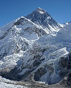 1. Mount Everest is the highest mountain peak on Earth.
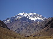
 3. Denali is the highest peak of North America.
 4. Kilimanjaro is the highest peak of Africa.
 6. The Vinson Massif is the highest peak of Antarctica.
 8. Mauna Kea on the Island of Hawaiʻi is the tallest mountain on Earth as measured from base on seafloor to summit.
 11. Thabana Ntlenyana in Lesotho is the highest point in southern Africa.
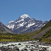
 12. Ma′unga Terevaka is the highest point on Easter Island.
 13. Mont Blanc is the highest peak of Western Europe.
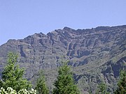 14. Piton des Neiges is the apex of Réunion.
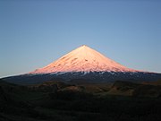 15. Klyuchevskaya Sopka is the highest peak of Kamchatka.
 16. Pico de Orizaba is the highest peak of Mexico.
 17. Queen Mary's Peak is the highest point on the Atlantic island of Tristan da Cunha.
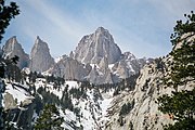 18. Mount Whitney is the highest peak of the contiguous United States.
 19. Gunung Kinabalu is the apex of Borneo.
 20. Mount Elbrus is the highest peak of Europe.
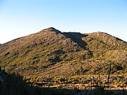 21. Pico da Bandeira is the third highest peak of Brazil.
 22. Mount Cameroon is the highest peak of Cameroon.


See also edit
References edit
- ^ Kirmse, Andrew; de Ferranti, Jonathan (December 2017). "Calculating the prominence and isolation of every mountain in the world". Progress in Physical Geography: Earth and Environment. 41 (6): 788–802. doi:10.1177/0309133317738163. Retrieved 8 May 2024.
- ^ Nearest higher neighbour in glossary on www.peakbagger.com
- ^ "Most Isolated Peak of Europe Countries - Peakbagger.com".
- ^ "Europe Ultra-Prominences". Peaklist. Retrieved 26 February 2015.
External links edit
🔥 Top keywords: Akademia e Shkencave e RPS te ShqiperiseAlexandria Ocasio-CortezBilderberg GroupCristiano RonaldoDong XiaowanMinecraftOperation GladioPrimal cutRiot FestStrictly Come Dancing (series 7)Main PageSpecial:SearchDonald TrumpWikipedia:Featured picturesLuka DončićCleopatraProsecution of Donald Trump in New YorkDeaths in 2024Kyrie IrvingStormy DanielsDrew Gordon2024 South African general electionYouTube2024 Indian general electionJuan MerchanFuriosa: A Mad Max SagaProject 2025EminemInughuit2024 ICC Men's T20 World CupKepler's Supernova.xxxMichael FinleyStormy Daniels–Donald Trump scandalJason KiddDallas MavericksEric (miniseries)Neatsville, KentuckyThe First OmenCivil War (film)Todd BlancheAlesha DixonPortal:Current eventsXXX (2002 film)Michael Cohen (lawyer)List of digital camera brandsBiggest ball of twine2024 United States presidential electionList of NBA champions