
Size of this preview: 388 × 599 pixels. Other resolutions: 155 × 240 pixels | 311 × 480 pixels | 497 × 768 pixels | 663 × 1,024 pixels | 1,884 × 2,910 pixels.
Original file (1,884 × 2,910 pixels, file size: 339 KB, MIME type: image/png)
| This is a file from the Wikimedia Commons. Information from its description page there is shown below. Commons is a freely licensed media file repository. You can help. |
Summary
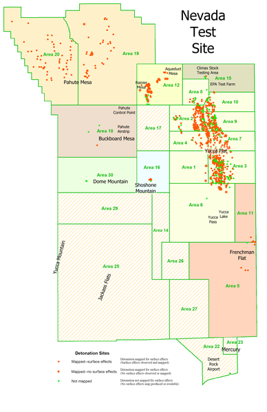
| Description | English: This is a derivative work. It is my retooling of a USGS map called "Geologic Surface Effects of Underground Nuclear Testing, Buckboard Mesa, Climax Stock, Dome Mountain, Frenchman Flat, Rainier/Aqueduct Mesa, and Shoshone Mountain, Nevada Test Site, Nevada." |
| Date | |
| Source | http://pubs.usgs.gov/of/2003/ofr-03-125/ |
| Author | Dennis N. Grasso, USGS |
| Permission (Reusing this file) | public domain |
| Other versions | http://pubs.usgs.gov/of/2003/ofr-03-125/ofr-03-125.pdf |
Licensing
This image is in the public domain in the United States because it only contains materials that originally came from the United States Geological Survey, an agency of the United States Department of the Interior. For more information, see the official USGS copyright policy. |
File history
Click on a date/time to view the file as it appeared at that time.
| Date/Time | Thumbnail | Dimensions | User | Comment | |
|---|---|---|---|---|---|
| current | 20:45, 8 July 2008 | | 1,884 × 2,910 (339 KB) | Binksternet | {{Information |Description={{en|1=This is a derivative work. It is my retooling of a USGS map called "Geologic Surface Effects of Underground Nuclear Testing, Buckboard Mesa, Climax Stock, Dome Mountain, Frenchman Flat, Rainier/Aqueduct Mesa, and Shoshone |
File usage
The following pages on the English Wikipedia use this file (pages on other projects are not listed):
Global file usage
The following other wikis use this file:
- Usage on de.wikipedia.org
- Usage on eo.wikipedia.org
- Usage on he.wikipedia.org
- Usage on lb.wikipedia.org
- Usage on no.wikipedia.org
- Usage on ru.wikipedia.org
- Usage on uk.wikipedia.org
- Usage on vi.wikipedia.org
🔥 Top keywords: Akademia e Shkencave e RPS te ShqiperiseAlexandria Ocasio-CortezBilderberg GroupCristiano RonaldoDong XiaowanMinecraftOperation GladioPrimal cutRiot FestStrictly Come Dancing (series 7)Main PageSpecial:SearchWikipedia:Featured picturesIga ŚwiątekRamoji RaoHit Man (2023 film)Pawan KalyanMichael Mosley (broadcaster)2024 Indian general electionWilliam AndersChirag PaswanCleopatraJasmine PaoliniPat SajakProject 20252024 ICC Men's T20 World CupDeaths in 2024Glen PowellKidnapping of Noa ArgamaniAdria ArjonaBad Boys: Ride or DieEarthriseVanna WhiteThe Acolyte (TV series)UEFA Euro 2024YouTubeThe Watchers (film)Beechcraft T-34 MentorSabrina CarpenterNormandy landingsBarry Keoghan.xxxGodzilla Minus OneTaylor SwiftN. Chandrababu NaiduClash at the Castle: ScotlandICC Men's T20 World CupTom Jones (singer)LAC Colombia Flight 028