No higher resolution available.
Subtropicalridge2000091412.jpg (622 × 282 pixels, file size: 26 KB, MIME type: image/jpeg)
| This is a file from the Wikimedia Commons. Information from its description page there is shown below. Commons is a freely licensed media file repository. You can help. |
Summary
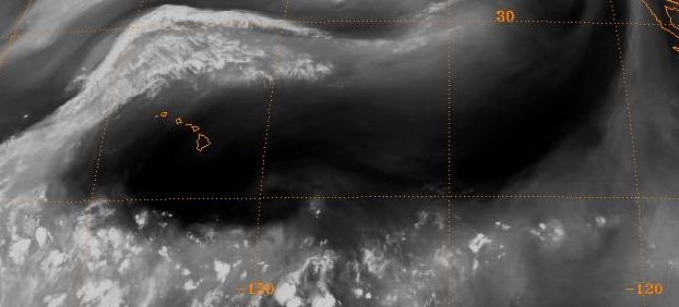
| Description | English: Water vapor imagery depiction of the subtropical ridge National Climatic Data Center's GIBBS satellite archive ftp://eclipse.ncdc.noaa.gov/pub/isccp/b1/.D2790P/images/2000/258/Img-2000-09-14-12-GOE-10-WV.jpg |
| Source | NOAA |
| Author | NOAA |
Licensing
This image is in the public domain because it contains materials that originally came from the U.S. National Oceanic and Atmospheric Administration, taken or made as part of an employee's official duties. |
Original upload log
The original description page was here. All following user names refer to en.wikipedia.
- 2007-02-11 14:35 Thegreatdr 622×282× (26734 bytes) Water vapor imagery depiction of the subtropical ridge National Climatic Data Center's GIBBS satellite archive ftp://eclipse.ncdc.noaa.gov/pub/isccp/b1/.D2790P/images/2000/258/Img-2000-09-14-12-GOE-10-WV.jpg
File history
Click on a date/time to view the file as it appeared at that time.
| Date/Time | Thumbnail | Dimensions | User | Comment | |
|---|---|---|---|---|---|
| current | 14:16, 6 August 2010 | | 622 × 282 (26 KB) | File Upload Bot (Magnus Manske) | {{BotMoveToCommons|en.wikipedia|year={{subst:CURRENTYEAR}}|month={{subst:CURRENTMONTHNAME}}|day={{subst:CURRENTDAY}}}} {{Information |Description={{en|Water vapor imagery depiction of the subtropical ridge National Climatic Data Center's GIBBS satellite |
File usage
The following pages on the English Wikipedia use this file (pages on other projects are not listed):
Global file usage
The following other wikis use this file:
- Usage on beta.wikiversity.org
- Usage on en.wikiversity.org
- Usage on es.wikipedia.org
- Usage on fr.wikipedia.org
- Usage on nn.wikipedia.org
- Usage on ru.wikipedia.org
- Usage on vi.wikipedia.org
- Usage on zh.wikipedia.org