
Size of this preview: 420 × 599 pixels. Other resolutions: 168 × 240 pixels | 550 × 785 pixels.
Original file (550 × 785 pixels, file size: 65 KB, MIME type: image/png)
| This is a file from the Wikimedia Commons. Information from its description page there is shown below. Commons is a freely licensed media file repository. You can help. |
Summary
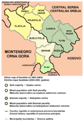
English: Ethnic map of Sandžak in 2002-2003.
Српски / srpski: Etnička mapa Sandžaka 2002-2003. godine.
Crnogorski: Etnička mapa Sandžaka 2002-2003. godine.
Bosanski: Etnička mapa Sandžaka 2002-2003. godine.
Source and license
 | This map has been uploaded by Electionworld from en.wikipedia.org to enable the |
Self-made map by PANONIAN
| This work has been released into the public domain by its author, PANONIAN. This applies worldwide. In some countries this may not be legally possible; if so: |
References
- Popis stanovništva, domaćinstava i stanova u 2002., Stanovništvo - knjiga 1, Nacionalna ili etnička pripadnost - podaci po naseljima, Republika Srbija, Republički zavod za statistiku, Beograd, 2003.
- Popis stanovništva, domaćinstava i stanova u 2003., Stanovništvo - knjiga 1, Nacionalna ili etnička pripadnost - podaci po naseljima i opštinama, Republika Crna Gora, Zavod za statistiku, Podgorica, 2004.
- Slobodan Radovanović, Geografski atlas, Magic Map, Smederevska Palanka, 2001.
- Geografski atlas, Intersistem kartografija, Beograd, 2004.
File history
Click on a date/time to view the file as it appeared at that time.
| Date/Time | Thumbnail | Dimensions | User | Comment | |
|---|---|---|---|---|---|
| current | 09:13, 21 May 2013 | | 550 × 785 (65 KB) | PANONIAN | improved version |
| 17:38, 9 March 2008 |  | 473 × 578 (63 KB) | Gugganij | highlighted Serbian-Montenegrin border | |
| 21:42, 21 December 2006 |  | 473 × 578 (67 KB) | Electionworld | {{ew|en|PANONIAN}} Self-made map by PANONIAN {{PD-user|PANONIAN}} Category:Maps of Serbia Category:Maps of Montenegro |
File usage
The following pages on the English Wikipedia use this file (pages on other projects are not listed):
Global file usage
The following other wikis use this file:
- Usage on bs.wikipedia.org
- Usage on ca.wikipedia.org
- Usage on fa.wikipedia.org
- Usage on gl.wikipedia.org
- Usage on he.wikipedia.org
- Usage on hr.wikipedia.org
- Usage on it.wikipedia.org
- Usage on ja.wikipedia.org
- Usage on lt.wikipedia.org
- Usage on mk.wikipedia.org
- Usage on no.wikipedia.org
- Usage on sh.wikipedia.org
- Usage on sr.wikipedia.org
- Usage on tr.wikipedia.org
- Usage on uk.wikipedia.org
🔥 Top keywords: Akademia e Shkencave e RPS te ShqiperiseAlexandria Ocasio-CortezBilderberg GroupCristiano RonaldoDong XiaowanMinecraftOperation GladioPrimal cutRiot FestStrictly Come Dancing (series 7)Main PageSpecial:SearchDonald SutherlandWikipedia:Featured picturesUEFA Euro 2024Kiefer Sutherland2024 Copa AméricaCleopatraTimothy MellonDeaths in 2024Copa AméricaDonald Sutherland filmographyUEFA European ChampionshipReggie JacksonJJ RedickChappell RoanRumpelstiltskinShirley DouglasRickwood FieldRossif SutherlandInside Out 2Taylor WilyFrancine RacetteHouse of the DragonSherri Papini kidnapping hoaxYouTubeWillie MaysThe Boys season 4The Boys (TV series)Sarah SutherlandAngus Sutherland (actor)Sabrina CarpenterNico WilliamsAntoine GriezmannThe Bikeriders2024 ICC Men's T20 World CupChristine ChubbuckOpinion polling for the 2024 United Kingdom general electionProject 2025