
Size of this preview: 337 × 599 pixels. Other resolutions: 135 × 240 pixels | 270 × 480 pixels | 432 × 768 pixels | 576 × 1,024 pixels | 2,094 × 3,723 pixels.
Original file (2,094 × 3,723 pixels, file size: 3.34 MB, MIME type: image/jpeg)
| This is a file from the Wikimedia Commons. Information from its description page there is shown below. Commons is a freely licensed media file repository. You can help. |
Summary
| Description | Español: Extremo superior del Obelisco de Buenos Aires, intersección de las avenidas Corrientes y 9 de Julio, barrio de San Nicolás, Buenos Aires, Argentina. English: Top of the Obelisk of Buenos Aires, intersection of Corrientes and 9 de Julio Avenues, San Nicolás neighborhood, Buenos Aires, Argentina. |
| Date | |
| Source | Own work |
| Author | ProtoplasmaKid |
| Other versions | TIFF version of the photo: 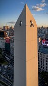 |
| Camera location | | View this and other nearby images on: OpenStreetMap |
|---|
| | Esta imagen o video fue tomado con un dron de Wikimedia México adquirido gracias a una subvención de la Fundación Wikimedia. Si usted considera este material útil o interesante considere donar. Puede ver otros trabajos producidos con estos equipos en este enlace.
|
Licensing
I, the copyright holder of this work, hereby publish it under the following license:
This file is licensed under the Creative Commons Attribution-Share Alike 4.0 International license.
- You are free:
- to share – to copy, distribute and transmit the work
- to remix – to adapt the work
- Under the following conditions:
- attribution – You must give appropriate credit, provide a link to the license, and indicate if changes were made. You may do so in any reasonable manner, but not in any way that suggests the licensor endorses you or your use.
- share alike – If you remix, transform, or build upon the material, you must distribute your contributions under the same or compatible license as the original.
This image has been assessed using the Quality image guidelines and is considered a Quality image. |
File history
Click on a date/time to view the file as it appeared at that time.
| Date/Time | Thumbnail | Dimensions | User | Comment | |
|---|---|---|---|---|---|
| current | 17:52, 13 May 2024 | | 2,094 × 3,723 (3.34 MB) | ProtoplasmaKid | Geometrical correction in the right top side. |
| 03:43, 9 May 2024 |  | 2,094 × 3,723 (3.33 MB) | ProtoplasmaKid | Uploaded own work with UploadWizard |
File usage
The following pages on the English Wikipedia use this file (pages on other projects are not listed):
Global file usage
The following other wikis use this file:
- Usage on es.wikipedia.org
Metadata
🔥 Top keywords: Akademia e Shkencave e RPS te ShqiperiseAlexandria Ocasio-CortezBilderberg GroupCristiano RonaldoDong XiaowanMinecraftOperation GladioPrimal cutRiot FestStrictly Come Dancing (series 7)Main PageSpecial:SearchWikipedia:Featured picturesJayson TatumJuneteenthUEFA Euro 2024Jaylen BrownAl HorfordBoston CelticsJoe MazzullaList of NBA championsCristiano RonaldoHouse of the DragonPage 3Noam ChomskyJrue HolidayCleopatraDeaths in 2024.xxxArda GülerPepe (footballer, born 1983)Inside Out 2Georgia (country)MāuiBo DallasBridgertonUEFA European ChampionshipCzech RepublicJustin Timberlake2024 NBA FinalsYouTubeFrancisco ConceiçãoKristaps PorziņģisThe Boys (TV series)Chad GableRoberto MartínezNoam chomskyDerrick White (basketball)Anouk Aimée