
Size of this PNG preview of this SVG file: 527 × 599 pixels. Other resolutions: 211 × 240 pixels | 422 × 480 pixels | 676 × 768 pixels | 901 × 1,024 pixels | 1,802 × 2,048 pixels | 938 × 1,066 pixels.
Original file (SVG file, nominally 938 × 1,066 pixels, file size: 104 KB)
| This is a file from the Wikimedia Commons. Information from its description page there is shown below. Commons is a freely licensed media file repository. You can help. |
This W3C-unspecified vector image was created with Inkscape .
Summary
| Description | |
| Date | |
| Source | Brunei map-en.svg |
| Author | Tachymètre (talk) |
Licensing
| This work has been released into the public domain by its author, Tachymètre. This applies worldwide. In some countries this may not be legally possible; if so: |
File history
Click on a date/time to view the file as it appeared at that time.
| Date/Time | Thumbnail | Dimensions | User | Comment | |
|---|---|---|---|---|---|
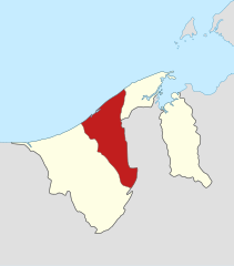
| current | 14:00, 26 February 2011 | | 938 × 1,066 (104 KB) | Tachymètre | {{Created with Inkscape}} == {{int:filedesc}} == {{Information |Description= {{en|Locator map of Tutong in Brunei.}} {{de|Lage von Tutong in Brunei.}} {{fr|Carte géolocalisée de [[:fr: |
File usage
The following pages on the English Wikipedia use this file (pages on other projects are not listed):
Global file usage
The following other wikis use this file:
- Usage on ar.wikipedia.org
- Usage on ast.wikipedia.org
- Usage on bcl.wikipedia.org
- Usage on bg.wikipedia.org
- Usage on bn.wikipedia.org
- Usage on cs.wikipedia.org
- Usage on de.wikipedia.org
- Usage on de.wikivoyage.org
- Usage on el.wikipedia.org
- Usage on es.wikipedia.org
- Usage on eu.wikipedia.org
- Usage on fi.wikipedia.org
- Usage on frr.wikipedia.org
- Usage on fr.wikipedia.org
- Usage on he.wikipedia.org
- Usage on it.wikipedia.org
- Usage on ko.wikipedia.org
- Usage on lv.wikipedia.org
- Usage on ms.wikipedia.org
- Usage on nl.wikipedia.org
- Usage on no.wikipedia.org
- Usage on pl.wikipedia.org
- Usage on ru.wikipedia.org
- Usage on simple.wikipedia.org
- Usage on sv.wikipedia.org
- Usage on th.wikipedia.org
- Usage on tr.wikipedia.org
- Usage on uk.wikipedia.org
- Usage on www.wikidata.org
- Usage on zh-min-nan.wikipedia.org
- Usage on zh-yue.wikipedia.org
- Usage on zh.wikipedia.org
🔥 Top keywords: Akademia e Shkencave e RPS te ShqiperiseAlexandria Ocasio-CortezBilderberg GroupCristiano RonaldoDong XiaowanMinecraftOperation GladioPrimal cutRiot FestStrictly Come Dancing (series 7)Main PageSpecial:SearchDonald SutherlandWikipedia:Featured picturesUEFA Euro 2024Kiefer Sutherland2024 Copa AméricaCleopatraTimothy MellonDeaths in 2024Copa AméricaDonald Sutherland filmographyUEFA European ChampionshipReggie JacksonJJ RedickChappell RoanRumpelstiltskinShirley DouglasRickwood FieldRossif SutherlandInside Out 2Taylor WilyFrancine RacetteHouse of the DragonSherri Papini kidnapping hoaxYouTubeWillie MaysThe Boys season 4The Boys (TV series)Sarah SutherlandAngus Sutherland (actor)Sabrina CarpenterNico WilliamsAntoine GriezmannThe Bikeriders2024 ICC Men's T20 World CupChristine ChubbuckOpinion polling for the 2024 United Kingdom general electionProject 2025