Size of this preview: 800 × 521 pixels. Other resolutions: 320 × 209 pixels | 640 × 417 pixels | 884 × 576 pixels.
Original file (884 × 576 pixels, file size: 598 KB, MIME type: image/jpeg)
| This is a file from the Wikimedia Commons. Information from its description page there is shown below. Commons is a freely licensed media file repository. You can help. |
Summary
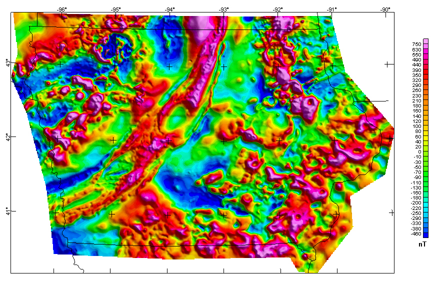
| Description | English: Iowa Composite Magnetic Anomaly Map (NE illumination) at simulated flight altitude of 305 m (1,000 ft) above ground |
| Date | (UTC) |
| Source | https://mrdata.usgs.gov/catalog/cite-view.php?cite=64 |
| Author | Kucks, Robert P. and Hill, Patricia L., U.S. Geological Survey |
Licensing
This image is in the public domain in the United States because it only contains materials that originally came from the United States Geological Survey, an agency of the United States Department of the Interior. For more information, see the official USGS copyright policy. |
Original upload log
The original description page was here. All following user names refer to en.wikipedia.
| Date/Time | Dimensions | User | Comment |
|---|---|---|---|
| 2009-09-03 20:03 | 884×576× (612399 bytes) | Billwhittaker | {{Information |Description = Iowa Composite Magnetic Anomaly Map (NE illumination) at simulated flight altitude of 305 m (1,000 ft) above ground |Source = http://tin.er.usgs.gov/catalog/cite-view.php?cite=64 |Date = ~~~~~ |Author |
File history
Click on a date/time to view the file as it appeared at that time.
| Date/Time | Thumbnail | Dimensions | User | Comment | |
|---|---|---|---|---|---|
| current | 01:23, 10 January 2017 | | 884 × 576 (598 KB) | BD2412 | Transferred from en.wikipedia |
File usage
The following pages on the English Wikipedia use this file (pages on other projects are not listed):
Global file usage
The following other wikis use this file:
- Usage on fr.wikipedia.org
- Usage on hy.wikipedia.org
- Usage on it.wikipedia.org
- Usage on ja.wikipedia.org
- Usage on ru.wikipedia.org
Metadata
🔥 Top keywords: Akademia e Shkencave e RPS te ShqiperiseAlexandria Ocasio-CortezBilderberg GroupCristiano RonaldoDong XiaowanMinecraftOperation GladioPrimal cutRiot FestStrictly Come Dancing (series 7)Main PageSpecial:SearchWikipedia:Featured picturesJayson TatumJuneteenthUEFA Euro 2024Jaylen BrownAl HorfordBoston CelticsJoe MazzullaList of NBA championsCristiano RonaldoHouse of the DragonPage 3Noam ChomskyJrue HolidayCleopatraDeaths in 2024.xxxArda GülerPepe (footballer, born 1983)Inside Out 2Georgia (country)MāuiBo DallasBridgertonUEFA European ChampionshipCzech RepublicJustin Timberlake2024 NBA FinalsYouTubeFrancisco ConceiçãoKristaps PorziņģisThe Boys (TV series)Chad GableRoberto MartínezNoam chomskyDerrick White (basketball)Anouk Aimée