Size of this preview: 662 × 599 pixels. Other resolutions: 265 × 240 pixels | 530 × 480 pixels | 848 × 768 pixels | 1,131 × 1,024 pixels | 1,308 × 1,184 pixels.
Original file (1,308 × 1,184 pixels, file size: 1.79 MB, MIME type: image/jpeg)
| This is a file from the Wikimedia Commons. Information from its description page there is shown below. Commons is a freely licensed media file repository. You can help. |
Summary
This is an image of a place or building that is listed on the National Register of Historic Places in the United States of America. Its reference number is 89000072. |
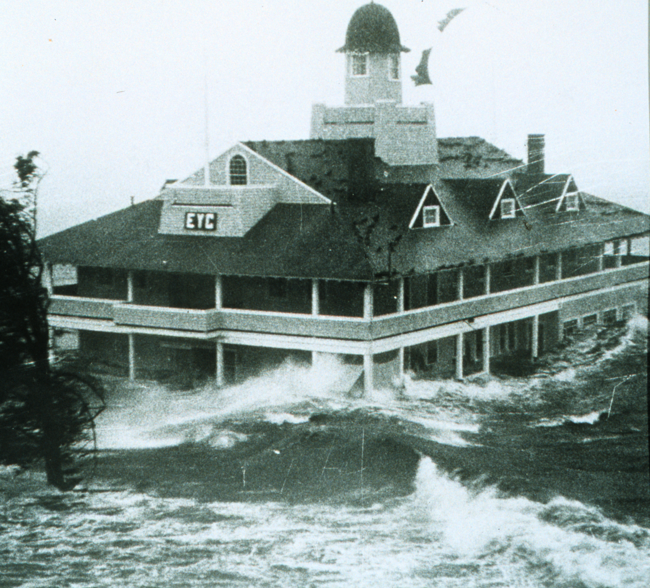
Storm surge from w:Hurricane Carol lashes the Edgewood Yacht Club. Author unknown.
Source: NOAA Photo Library
Licensing
This image is in the public domain because it contains materials that originally came from the U.S. National Oceanic and Atmospheric Administration, taken or made as part of an employee's official duties. |
| Object location | | View this and other nearby images on: OpenStreetMap |
|---|
File history
Click on a date/time to view the file as it appeared at that time.
| Date/Time | Thumbnail | Dimensions | User | Comment | |
|---|---|---|---|---|---|
| current | 03:25, 26 December 2005 | | 1,308 × 1,184 (1.79 MB) | Jdorje~commonswiki | Storm surge from Hurricane Carol lashes the Rhode Island Yacht Club. Source: [http://www.photolib.noaa.gov/historic/nws/wea00407.htm NOAA Photo Library] == Licensing == {{PD-USGov-NOAA}} |
File usage
More than 100 pages use this file.The following list shows the first 100 pages that use this file only.A full list is available.
- Hurricane Carol
- List of New England hurricanes
- List of retired Atlantic hurricane names
- Talk:1878 flood in Miskolc
- Talk:1887 Yellow River flood
- Talk:1931 China floods
- Talk:1938 Yellow River flood
- Talk:1966 flood of the Arno
- Talk:1971 Kuala Lumpur floods
- Talk:1974 Brisbane flood
- Talk:1978 Singapore flood
- Talk:1997 Red River flood
- Talk:1997 Red River flood in the United States
- Talk:1998 China floods
- Talk:1999 Vietnamese floods
- Talk:2000 Mozambique flood
- Talk:2002 European floods
- Talk:2003 Santa Fe flood
- Talk:2004 Boscastle flood
- Talk:2005 European floods
- Talk:2005 Gujarat flood
- Talk:2006 European floods
- Talk:2006 Mid-Atlantic United States flood
- Talk:2006 New England flood
- Talk:2006 North Korean floods
- Talk:2006–2007 Southeast Asian floods
- Talk:2007 African floods
- Talk:2007 Chittagong mudslides
- Talk:2007 Midwest flooding
- Talk:2007 Mozambican flood
- Talk:2007 North Korean floods
- Talk:2007 South Asian floods
- Talk:2007 Sudan floods
- Talk:2007 Tabasco flood
- Talk:2007 United Kingdom floods
- Talk:All Saints' Flood (1570)
- Talk:Banqiao Dam
- Talk:Bonnet Carré Crevasse
- Talk:Buffalo Creek flood
- Talk:Burchardi flood
- Talk:Channeled Scablands
- Talk:Color-tagged structure
- Talk:Drop (liquid)
- Talk:Flash flood
- Talk:Flash flood warning
- Talk:Flood Control Act of 1944
- Talk:Flood control in the Netherlands
- Talk:Flood insurance
- Talk:Floods in Australia
- Talk:Floods in Malaysia
- Talk:Floods in the United States (1900–1999)
- Talk:Floods in the United States (2000–present)
- Talk:Floods in the United States before 1900
- Talk:Glacial Lake Missoula
- Talk:Glacial lake outburst flood
- Talk:Great Dayton Flood
- Talk:Great Flood of 1844
- Talk:Great Flood of 1951
- Talk:Great Flood of 1993
- Talk:Great Mississippi Flood of 1927
- Talk:Great Sheffield Flood
- Talk:Hatlestad Slide
- Talk:History of flooding in Canada
- Talk:Johnstown Flood
- Talk:June 2007 Texas flooding
- Talk:Ka Loko Reservoir
- Talk:Kelly Barnes Dam
- Talk:Kissimmee River
- Talk:Levee
- Talk:List of floods
- Talk:List of floods in the Netherlands
- Talk:Lists of floods in the United States
- Talk:Los Angeles flood of 1938
- Talk:Maharashtra floods of 2005
- Talk:March 2007 floods in Argentina's Litoral region
- Talk:Maumee Torrent
- Talk:May 1995 Louisiana flood
- Talk:Meramec River
- Talk:Ministry of Water Resources (China)
- Talk:Missoula floods
- Talk:Napa River flood of 1986
- Talk:National Flood Insurance Program
- Talk:North Sea flood of 1953
- Talk:North Sea flood of 1962
- Talk:North Sea flood of 2007
- Talk:Northeast U.S. flooding of October 2005
- Talk:Pittsburgh flood of 1936
- Talk:Sauvé's Crevasse
- Talk:St. Elizabeth's flood (1404)
- Talk:St. Elizabeth's flood (1421)
- Talk:St. Felix's flood
- Talk:St. Lucia's flood
- Talk:Storm tides of the North Sea
- Talk:United States rainfall climatology
- Talk:Willamette Valley flood of 1996
- Wikipedia:WikiProject Severe weather
- Wikipedia:WikiProject Tropical cyclones
- Template talk:Infobox flood
- Category talk:Flood
- Category talk:Floods in Australia
View more links to this file.
Global file usage
The following other wikis use this file:
- Usage on ar.wikipedia.org
- Usage on ca.wikipedia.org
- Usage on es.wikipedia.org
- Usage on fr.wikipedia.org
- Usage on it.wikipedia.org
- Usage on nn.wikipedia.org
- Usage on no.wikipedia.org
- Usage on simple.wikipedia.org
- Usage on sv.wikipedia.org
- Usage on www.wikidata.org
- Usage on zh.wikipedia.org
- Portal:美國/特色條目
- Wikipedia:典范条目/2014年10月
- Wikipedia:优良条目/2014年12月
- 飓风卡罗尔
- Wikipedia:优良条目/2014年12月20日
- Wikipedia:优良条目/飓风卡罗尔
- Wikipedia:典范条目/2014年10月13日
- Wikipedia:典范条目/飓风卡罗尔
- Portal:美国/特色条目/208
- Wikipedia:典范条目/2016年12月
- Wikipedia:典范条目/2016年12月12日
- Wikipedia:典范条目/2019年5月1日
- Wikipedia:典范条目/2019年5月
- Wikipedia:典范条目/2023年3月
- Wikipedia:典范条目/2023年3月21日
Metadata
🔥 Top keywords: Akademia e Shkencave e RPS te ShqiperiseAlexandria Ocasio-CortezBilderberg GroupCristiano RonaldoDong XiaowanMinecraftOperation GladioPrimal cutRiot FestStrictly Come Dancing (series 7)Main PageSpecial:SearchDonald SutherlandWikipedia:Featured picturesUEFA Euro 2024Kiefer Sutherland2024 Copa AméricaCleopatraTimothy MellonDeaths in 2024Copa AméricaDonald Sutherland filmographyUEFA European ChampionshipReggie JacksonJJ RedickChappell RoanRumpelstiltskinShirley DouglasRickwood FieldRossif SutherlandInside Out 2Taylor WilyFrancine RacetteHouse of the DragonSherri Papini kidnapping hoaxYouTubeWillie MaysThe Boys season 4The Boys (TV series)Sarah SutherlandAngus Sutherland (actor)Sabrina CarpenterNico WilliamsAntoine GriezmannThe Bikeriders2024 ICC Men's T20 World CupChristine ChubbuckOpinion polling for the 2024 United Kingdom general electionProject 2025