Beureukaih:Location-Europe-UNsubregions, Kosovo as part of Serbia.png

Seunipat hasé peusaneut: 638 × 599 piksel Resolusi la'én: 256 × 240 piksel | 511 × 480 piksel | 984 × 924 piksel.
Beureukaih aseuli (984 × 924 piksel, rayek beureukaih: 50 KB, MIME jeunèh: image/png)
 | File:Europe subregion map UN geoscheme.svg merupakan versi vektor dari berkas ini. Berkas itu harus digunakan menggantikan gambar raster ini jika kualitasnya tidak rendah. File:Location-Europe-UNsubregions, Kosovo as part of Serbia.png → File:Europe subregion map UN geoscheme.svg Untuk informasi lanjutan, lihat Bantuan:SVG. |  |
 | This map has been uploaded by Electionworld from en.wikipedia.org to enable the |
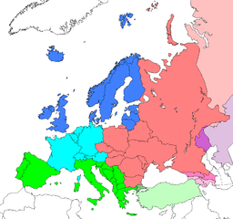
Map: Europe (location), subregions as delineated by United Nations geographic classification scheme:
- Asian portions of these countries
- Asian portions of these countries
Countries of Central Asia with partial territory in Eastern Europe – Kazakhstan
- Asian portions of these countries
Jeunèh lisensi
| Karya ini dilepaskan ke domain umum oleh pemiliknya, Electionworld. Lisensi ini berlaku di seluruh dunia. Di sejumlah negara, tindakan ini tidak memungkinkan secara sah; bila seperti itu: |
Log pengunggahan asli
| date/time | username | resolution | size | edit summary |
|---|---|---|---|---|
| 16:25, 10 June 2008 | User:Milosevo | 984×924 | 50 KB | STOP VANDALISING! KOSOVO ISN'T A UN MEMBER, SO KOSOVO CAN'T BE IN A UN SUBREGION! |
| 13:28, 10 June 2008 | User:Cradel | 638×599 | 166 KB | Reverted to version as of 20:44, 9 June 2008jere |
| 12:07, 10 June 2008 | User:Milosevo | 984×924 | 50 KB | Reverted, again: kosovo isn't UN member, so it can't be in an UN subregion. |
| 20:44, 9 June 2008 | User:Cradel | 638×599 | 166 KB | Reverted to version as of 20:16, 8 June 2008 |
| 14:15, 9 June 2008 | User:Milosevo | 984×924 | 50 KB | kosovo isn't a UN member, so it can't be in an UN subregion. |
| 20:16, 8 June 2008 | User:Cradel | 638×599 | 166 KB | Reverted to version as of 18:17, 1 May 2008 |
| 10:17, 8 June 2008 | User:Milosevo | 984×924 | 50 KB | Reverted to version as of 23:06, 30 April 2008 |
| 18:17, 1 May 2008 | User:Cradel | 638×599 | 166 KB | Reverted vandalism |
| 23:06, 30 April 2008 | User:Serbish | 984×924 | 50 KB | Reverted to version as of 23:01, 29 January 2008 |
| 20:53, 7 April 2008 | User:Cradel | 638×599 | 166 KB | + Kosovo |
| 23:01, 29 January 2008 | User:Mahahahaneapneap | 984×924 | 50 KB | pngcrushed |
| 14:46, 3 December 2006 | User:Electionworld | 984×924 | 73 KB | {{ew|en|Cogito ergo sumo}} Map: <a href="https://www.how.com.vn/wiki/ace/Europe" class="mw-redirect" title="Europe">Europe</a> (location), <a href="https://www.how.com.vn/wiki/?lang=ace&title=Subregion&action=edit&redlink=1" class="new" rel="nofollow" target="_blank" title="Subregion (page does not exist)">subregions</a> as delineated by [http://unstats.un.org/unsd/methods/m49/m49regin.htm United Nations geographic classification scheme]:<br> {{legend|#4080FF|<a href="https://www.how.com.vn/wiki/?lang=ace&title=Northern_Europe&action=edit&redlink=1" class="new" rel="nofollow" target="_blank" title="Northern Europe (page does not exist)">Northern Europe</a>}} {{legend|#00FFFF|[[Wes |
Riwayat beureukaih
Neuteugon bak uroe buleuen/watèe keu neu-eu beureukaih nyoe ‘oh watèe nyan.
| Uroe buleuen/Watèe | Beuntuk ubeut | Dimènsi | Ureueng ngui | Beunalaih | |
|---|---|---|---|---|---|
| jinoë hat | 8 Buleuen Lapan 2008 22.17 | | 984 × 924 (50 KB) | BetacommandBot | move approved by: User:Samulili This image was moved from Image:Location-Europe-UNsubregions.png {{ew|en|Cogito ergo sumo}} Map: Europe (location), subregions as delineated by [http://unstats.un.org/unsd/methods/m49/m49regin.htm United |
Seuneungui beureukaih
laman di yup nyoe mupawôt u beureukaih nyoe:
Neungui beureukaih global
Wiki laén di yup nyoe geungui beureukaih nyoe:
- Seuneungui bak af.wikipedia.org
- Seuneungui bak ar.wikipedia.org
- Seuneungui bak be-tarask.wikipedia.org
- Seuneungui bak be.wikipedia.org
- Seuneungui bak bg.wikipedia.org
- Seuneungui bak bn.wikipedia.org
- Seuneungui bak br.wikipedia.org
- Seuneungui bak bs.wikipedia.org
- Seuneungui bak ceb.wikipedia.org
- Seuneungui bak crh.wikipedia.org
- Seuneungui bak cy.wikipedia.org
- Seuneungui bak da.wikipedia.org
- Seuneungui bak en.wikipedia.org
- Seuneungui bak en.wikivoyage.org
- Seuneungui bak eo.wikipedia.org
- Seuneungui bak eu.wikipedia.org
- Seuneungui bak fa.wikipedia.org
- Seuneungui bak fi.wikipedia.org
- Seuneungui bak fr.wikipedia.org
- Seuneungui bak fy.wikipedia.org
- Seuneungui bak fy.wiktionary.org
- Seuneungui bak gag.wikipedia.org
- Seuneungui bak gd.wikipedia.org
- Seuneungui bak gl.wikipedia.org
- Seuneungui bak id.wikipedia.org
- Seuneungui bak io.wikipedia.org
Eu leubèh le neungui ban dum nibak beureukaih nyoe.
🔥 Top keywords: Ôn KeueBeunantu:AsoëWikipèdiaBeureukaih:Sura2.pdfWikipedia:MeusapatSurat Al-BaqarahSurat YasinSeunaleuëk:Country data CambodiaKusuih:MitaAustraliaABasa InggréhUreuëng Ngui:Ha98574/Header barUreuëng Ngui:Bennylin/Ôn KeuëUreuëng Ngui:Si Gam/Ôn KeuëUreuëng Ngui:AFlorence/1Wikipedia:On Keue 1Ureuëng Ngui:Srtq/On Keue DesignUreuëng Ngui:Ha98574Ureuëng Ngui:BotrieAmirika SyarikatSeunaleuëk:Bahsa la’énKitab-kitab AllahUreuëng Ngui:MazbelSeunaleuëk:Tampilan-Wiki HowTompiKusuih:Neuubah baroFacebookSeunaleuëk:Wikilon lam bahsa laenUreuëng Ngui:MinsbotWikipedia:Seunaleuëk/GambaOSUreuëng Ngui:Minsbot/Header barSeunaleuëk:BasmalahJavaUreuëng Ngui:Botrie/Header barInternètOLinux